Iceland: Weeks 42 + 43

For most of the last two weeks my parents have been in Iceland. After a couple of days in Reykjavík, we traveled around the country together, driving 1500 miles counter-clockwise on the Ring Road with excursions into Vestmannaeyjar, the Eastfjords, and around various peninsulas. They were on a tour of Iceland in 2021, so there was a little bit of overlap with that, but we did the kind of exploring that a tour would never support: driving down gravel roads deep into mountain passes, roaming the back streets of harbors in tiny fishing villages, tracking down sculptures in the mountains. A couple of years ago there would have been no way they’d be up for some of the hikes we did — up a volcano, on a glacier — but knee replacements do wonders and they have three new knees between them.

There were far too many great sites and moments to chronicle in one post, but I’ll touch on some of the highlights and things that were new to me. I have lots of photosets on Instagram if you want to see more.

On top of the Eldfell volcano in Vestmannaeyjar (Westman Islands).
Map of my road trip around Iceland with my parents in May 2026.

Our first stop was Vestmannaeyjar, which was the trickiest to plan around because the ferry is operating on a single engine and can’t make it across the strait in bad weather. Luckily the weather was good enough to sail there on schedule, but on advice from an agent at the ferry terminal I swapped our return trip the next day to be the first ferry out at 7am, in order to guarantee that we wouldn’t be trapped.

I love those islands, and was happy for another chance to hike up the Eldfell volcano to get a view of the whole archipelago. It was a lot greener when I was there last August, but this trip offered the chance to see a new site-specific artwork by Ólafur Elíasson that was installed earlier this month. It’s called “The Wanderer’s Perspective” and consists of two parts: a viewing sphere that frames the volcano, and a new walking path up to its summit (still in development). The walking path will follow the route of a giant piece of lava from the 1973 eruption that was nicknamed Flakkarinn (The Wanderer) because of how far it traversed across the landscape.

The viewing sphere is easily accessible, and frames the volcano in a way that the sun aligns with the volcano’s peak at 1:30pm on January 23, the exact date and time of the eruption. Circular holes in the roof trace the sun’s trajectory on July 3, the day the eruption was declared over.

“The Wanderer’s Perspective” by Ólafur Elíasson

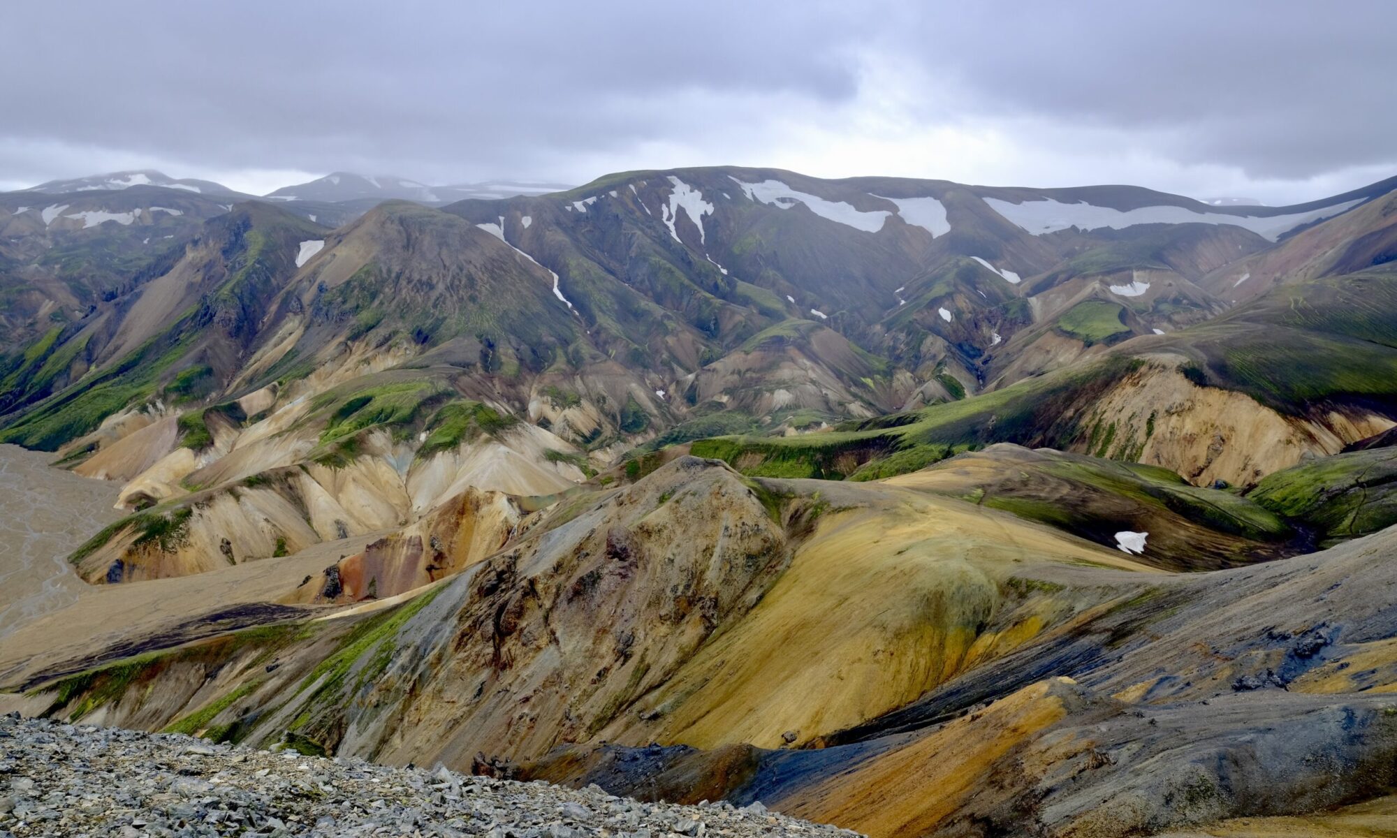
Leaving the Westman Islands we visited lots of spots along the south coast, and it turned out that the earlier ferry was a great idea because there’s so much to see along this stretch. We stopped by the Seljalandsfoss and Skógafoss waterfalls of course, but also the Sólheimajökull glacier, Reynisdrangar beach, and Hjörleifshöfði cave. The next day we hiked the Fjaðrárgljúfur canyon and walked on the Svínafellsjökull glacier before it started raining heavily. That may have contributed to lack of ice on Diamond Beach, but it was still fun to check out the massive icebergs in Jökulsárlón glacial lagoon.

My parents at Fjaðrárgljúfur canyon.
Svínafellsjökull glacier tongue
Jökulsárlón glacial lagoon

After staying in the night in Höfn, we drove into the Eastfjords the next day, venturing further east than I’d been in Iceland before. It immediately felt different for me, taking in new sites versus driving through ones I’d seen two to four times before. More firsts came fast, as this region is where the wild reindeer live and we added them to our animal sightings along with the pervasive sheep and horses. It was earlier enough in the year that their antlers were still velvety and we even spotted a couple of calves.

Reindeer in the Eastfjords
Two reindeer in the Eastfjords
A female reindeer and her calf, in the Eastfjords.

Also in the Eastfjords was Petra’s Stone Collection, an absolutely amazing place showcasing a single woman’s collection of rocks and minerals found all around Iceland over her lifetime. It is impossible to convey the size and scope of her collection but it’s like nothing I have ever seen. See my Instagram photoset for more.

Petra’s Stone Collection
I can’t believe how many colors and textures were in this one rock.

We stayed in Seyðisfjörður, which is reached by driving over a mountain pass that was still covered in deep snow. The town is where the Smyril Line ship arrives in Iceland after sailing from Denmark via the Faroe Islands. It’s also one of the two locations that were used in the Icelandic TV series Trapped, the other being Siglufjörður where we also stayed a few days later. I’m looking forward to rewatching the show now that I’ve spent time in both places.

Sheep with her lamb in Seyðisfjörður.

While there, we also hiked up the mountain to see Tvísöngur, a sound sculpture by the German artist Lukas Kühne that consists of a series of interconnected concrete domes. The plaque notes that it can be viewed as a visualization of the Icelandic five-tone harmony tradition, and dubs it “singing concrete.” The experience is that if you stand directly underneath each dome your voice resonates strongly back to you, in an effect that feels as if you have headphones on, piping your amplified words back into your ears. It’s a strikingly simple design but a really fun and powerful effect.

Tvísöngur sound sculpture

Nearby was another sculpture, squarely aligned with my interest in subsea cables, called “Hvernig gengur?” — How is it going? — and was commissioned by Iceland Telecom to commemorate the 100th anniversary of the first telegraph cable laid between Scotland and Iceland in 1906, which came ashore in Seyðisfjörður.

Hvernig gengur? sculpture.

Our next stop in the Eastfjords was Borgarfjörður Eystri, the puffin capital of Iceland, where an islet named Hafnarhólmi is home to thousands of burrows. Stairs and platforms allow visitors to walk around part of the islet, providing an extremely close up view of the puffins from every possible angle. When we arrived, this closeness already made it the best puffin site I’d been to, even surpassing Mykines on the Faroe Islands. But soon after 8pm a majority of the birds that had been out to sea returned, in a seemingly coordinated ritual. At that point the hills were absolutely swarmed, with puffins taking off and landing, going in and out of their burrows, billing their mate, and strutting around.

The crowd gathered to view them all seemed to understand what a special moment this was, adopting library-hushed speaking levels and careful footsteps; it was a quiet and reverent place. These funny little birds have the ability to make everyone smile as they awkwardly fly and waddle around on their bright orange feet.

Puffin at Borgarfjörður Eystri.
Puffin at Borgarfjörður Eystri about to take flight.
Puffin at Borgarfjörður Eystri with its mouth open.

As we started heading northwest, our first stop was the hike to Stuðlagil canyon. The water at this time of year isn’t the turquoise color you often see in photos, but the basalt columns along the river’s edge are stunning. If you’re thinking of going, I recommend hiking in on the east side of the canyon. The west side has more infrastructure, and you can drive up to the lookout spot, but there are still hundreds of steps down to the river and you can’t walk down into the canyon. You’ll see some of it, but most of the views will be just out of sight. The eastern side has a new parking lot further along the canyon, so it’s now only a ~3 miles hike instead of what used to be ~6 miles.

Stuðlagil canyon from the eastern bank
Stuðlagil canyon

As we headed west we started to get back into areas of North Iceland I’d visited in early April. We went to the Hverir geothermal area, visited the cows at Vogafjós Farm Resort, stayed on a farm near Lake Mývatn, and visited Goðafoss. There was a massive cruise ship docked in Akureyri, deploying 20+ full-size buses to the sites in the area. I’m not a fan of that kind of travel, or being around those kinds of crowds, so it was nice to head up the peninsula to Siglufjörður where we spent the last two nights of the trip.

It was rainy, and even snowed, the final two days — but that was okay. We stayed at the excellent Sigló hotel, which has a geothermal hot tub overlooking the harbor and mountains that is great in any weather. We also visited The Herring Era Museum, which has excellent artifacts from the town’s history when it was Iceland’s fish export epicenter.

Hot tub at the Sigló hotel in Siglufjörður.
Rainbow over Eyjafjörður.
Sauðanesviti lighthouse

As we headed back to Reykjavík we detoured to see the sea stack Hvitserkur. We also passed by one of the most interesting sheep roundup pens I’ve seen in Iceland, situated unusually right by the beach.

Hvitserkur sea stack
Sheep roundup pen by the ocean, just north of Hvammstangi on route 711.

The final trip was to the Reykjanes Peninsula, to drop my parents off at the airport but also to explore the area around Grindavík. We saw the fresh lava flows that covered the old road, as well as the magma barrier walls that surround the power plant and town.


Overall, it was a great trip around the country and I’m happy that I was able to do it with my parents. One of the interesting things about traveling with other people is that they notice different things than you do. When my brother visited Iceland he pointed out many aspects of the architecture that I hadn’t seen. My Mom notices artifacts, furniture, and how people construct their homes in ways that I might overlook. She also has an incredible eye for interesting rocks and was always finding good ones as we hiked. My Dad, not surprisingly, sees the farming activity in rural Iceland with a level of depth that most of us would overlook. I see the tractors, sheep, and hay bales but he’s looking at soil type, fertilizer composition, and water management practices. We all have our travel eccentricities — I did track down a monument to a telegraph cable after all — but it was interesting to see Iceland through their eyes.

Iceland: Weeks 21 + 22

This is my first Iceland post that needed to span multiple weeks. In the previous fortnight I wrapped up everything for my first semester at the University of Iceland and my brother visited for five days. It was really fun to have him here, his first time in Iceland, and despite the very minimal amount of sunlight (~3.5 hours per day) we had a great time exploring the Reykjanes Peninsula and south coast.

When I met Isaiah at the airport, at a little past 7am, we still had at least 3 hours before the sun would start peeking above the horizon, so we caught up in a cafe before heading out. Iceland immediately showed off its weather diversity as we drove from drizzly Keflavík through the snow-covered lava fields of Reykjanes. The first stop was more of a conceptual one, but established the mind-blowing geological newness that is Iceland: a bridge between continents that connects the Eurasian and North American tectonic plates. The country is basically split in two by these plates, the source of volcanic activity that led to the creation of Iceland 20 million years ago and all the continued eruptions today.

Bridge between the Eurasian and North American tectonic plates

Near there is Gunnuhver, a geothermal area, where the mixture of snow, steam, and sunrise seemed like a fitting introduction to Iceland.

Gunnuhver geothermal area
Isaiah at the Gunnuhver geothermal area
A graveyard along the Reykjanes southern coast. During Christmas cemeteries in Iceland are lit up like this.

This time of year the sun never really stops rising or setting, but by the time we arrived in Grindavík it was light enough to see the impact of the nine dramatic eruptions that caused the town’s 3,700 residents to flee in 2023. The town is surrounded by newly constructed lava barriers, and in the city center there’s a fissure that cracked and shifted the street by a meter or more. New roads have been cut through the lava, and there are signs of rebuilding, but most residents haven’t yet moved back.

A new road cut through the lava field, seen from the top of a lava barrier.
Isaiah on a lava field from the 2023 eruptions.

Our next stop was Hveragerði, where we hiked into the mountains to the Reykjadalur thermal river. The sun had already started to set when we started around 2:30pm, so we packed headlamps for the walk back. That was smart, but it would have been even smarter for us to not leave our crampons in the car. The ~5 mile round-trip hike was icier than we anticipated, but beautiful, and soaking in the hot springs surrounded by snow covered mountains felt amazing.

The view over the geothermal valley
Reykjadalur hike
Reykjadalur hot springs area. This is the main site for soaking, with a boardwalk and minimal changing zones.

We stayed in Reykjavík that first night, and the next morning made headway down the south coast before sunrise so we could maximize the minimal daylight. The weather was cooperative throughout the trip, with very little rain or snow. The temperature was moderate, mostly just above freezing, but the wind got up to 40 mph. At times, it felt like pushing on a heavy door just to walk forward and twice it literally knocked me to my knees.

The south coast did not disappoint, and it’s truly the biggest payoff for a limited amount of time in Iceland. It’s amazing how many things are just off the ring road, and while these accessible sites are busy with tourists, even in winter, it wasn’t overwhelming. We went to Seljalandsfoss, Skógafoss, Sólheimajökull, and Reynisfjara before running out of daylight in Vík, and continuing the drive to our hotel in Hof.

For this first day, I have photosets on Instagram of horses, Sólheimajökull, and Reynisfjara.

A herd of Icelandic horses congregated along the road and were happy to see us. I love how they are so genetically specific and yet each one has such a distinctive look.
The Eyjafjallajökull icecap, underneath is the volcano that erupted in 2010 and caused 20 countries to close their airspace.
Obligatory waterfall selfie. Unfortunately, this time of year they don’t let you go behind Seljalandsfoss due to icy conditions.
Sólheimajökull glacier, which I went ice climbing on just a month previous. It was fun to come back so soon and see the changes in the icebergs and lagoon.
I brought my other camera lens (50–200mm) along for this trip to Sólheimajökull, which let me capture slightly different views of the glacier than when I was there previously with only my 23mm.
This ice arch is an example of something that I didn’t see last month, and it probably won’t be there a month from now.
Very rough seas and intense wind at Reynisfjara, the black sand beach.
Basalt pillars on the Hálsanefshellir cave.
Black sand beach with Dyrhólaey in the distance.

At sunrise the next morning we went to the Jökulsárlón glacier lagoon and Diamond Beach, where icebergs calve off the glacier and float out to the sea, washing up on the black sand. It’s a stunning place, with bright blue ice that feels surreal amid the immensity of the Vatnajökull ice gap. I have a photoset on Instagram with more images.

An iceberg just off shore that hadn’t been washed onto the beach yet. I saw a photo someone took two days after this that looked like it had broken in two, with a large piece on the sand.
Ice chunk on Diamond Beach in pre-dawn light.
Jökulsárlón glacier lagoon

Perhaps the most unexpected experience was going to the Fjallsárlón glacier lagoon and realizing it was frozen solid. The Jökulsárlón lagoon doesn’t freeze in winter, because it mixes with salt water from the ocean, so after cresting the hill that reveals Fjallsárlón it was almost hard to process what we were seeing: massive icebergs, frozen in place, with people walking amongst them.

It’s pretty amazing that in a short two-day trip we were able to visit three different outlet glaciers. Whether it’s winter or not, my top tip for the south coast of Iceland is to not miss Fjallsárlón, if you are going all the way to Jökulsárlón. It’s only 15 minutes west and an equally wonderful experience. I also have a separate photoset of Fjallsárlón on Instagram.

A frozen glacier lagoon at Fjallsárlón
The Fjallsárlón glacier
A blue-ice arch in and iceberg at the Fjallsárlón glacier lagoon

The final stop on our south coast tour was Fjaðrárgljúfur canyon, where a winding river has cut a scenic path. I somewhat sheepishly realized that I first learned about this place because it’s the splash screen on my banking app, which feels like finding out about national parks from MacOS wallpaper. But it’s a beautiful spot, and definitely worth the hour or so if you have the time (and daylight) to spare.

Fjaðrárgljúfur canyon

I have lots more photos, but this post is already very long. Overall, it was great to have Isaiah visit and nice to see spots on the south coast that I hadn’t yet visited during this time in Iceland. I went as far east as I’ve ever been, but no further. This Spring I’m hoping to break that barrier and make it all the way to the Eastfjords.

Outside of our roadtrip we walked around Reykjavík, which made me realize just how small it is. By day two of exploring the city we had gone to 80% of the areas I frequent, ate well, and avoided spending too much time in my tiny studio apartment. It’s always interesting to wander around a city with Isaiah because as an architect he sees things in the built environment that I don’t. We have similar but different designer afflictions: I spot the bad kerning on signs, he notices when courtyards don’t align. But he also looks up who designed the buildings, so now I realize that every day I walk by three or four buildings by Guðjón Samúelsson.


I’ll be traveling to the U.S. for the holidays, my first time leaving Iceland since I arrived in mid-July. I realized this week that my time here matches my longest living out of the country; I was in India during 2011 for the exact same time period. I’ll be in the States for three weeks, returning just before the next semester starts on January 12th. I’m probably going to take a break from writing here during that time. Happy new year to everyone that’s been reading this blog. I appreciate hearing from you, thank you for following along.

Noted & Done

  • Iceland will not take part in next year’s Eurovision, in protest of Israel’s participation.
  • UNESCO has added Icelandic swimming pool culture to its list of intangible cultural heritage of humanity.
  • Icelandic sculptor Steinunn Thórarinsdóttir did a talk at Scandinavia House in NYC last month and the video is now online.
  • Finished Shetland season 10, which was very much like every other season but that’s fine with me. I watch it as much for the landscapes as I do for the plot.
  • Finished my two research papers and will heartily recommend Zotero for managing sources, notes, and most of all footnotes. I honestly don’t know how I would have managed my footnotes and bibliography formatting without this tool. One of those pieces of software that you immediately can not imagine living without.

Iceland: Week 17

I finally got to walk on a glacier. I’ve seen them from a distance when hiking alongside their imposing presence on the Laugavegur trail, and up close on a boat to the calving front in the Jökulsárlón glacial lagoon. I have memories of a planned glacier walk in Alaska that was scrapped when I was twelve years old, visiting my Aunt Debi with my grandparents, but that was too long ago to even remember the circumstances. This week I finally got on top of (and even inside!) the glacier Sólheimajökull, an outlet of the the larger Mýrdalsjökull ice dome sitting atop the Katla volcano.

Sólheimajökull terminus
Icebergs reflecting in the glacial lagoon

 Sólheimajökull is probably the most accessible glacier in Iceland, which is why I was able to visit it on a day-trip from Reykjavík. It’s a skinny, 12 km long valley, that terminates in a glacial lagoon that wasn’t even there in 2009, but grows 50 meters larger ever year as the glacier retreats due to rapid melting since the turn of the century. There is a timelapse video on Vimeo that captures the change from 2007 to 2018, and the Glacier Change website has numerous slide-over comparison photos, the most dramatic of which compares photographs from 1930 and 2023. My guide thought there may be only a couple more years where it will be possible to access the ice from easy approach we took, as the front pulls away into the valley.

The surface of Sólheimajökull is partly covered by black volcanic ash from the nearby Katla volcano, which hasn’t had a major eruption since 1918. Thin layers of ash can accelerate the melting of of the ice, since the darkened surface lowers reflectivity and increases heat absorption. But if the layer of ash is thick enough it can actually slow melting by acting as an insulating blanket.

Ash covering on the Sólheimajökull glacier

Once you get past the lagoon and actually up glacier the thickness of the ice becomes more obvious. What isn’t apparent when looking at the lagoon is that it’s 60 meters deep, which as our guide pointed out is nearly the height of the Hallgrímskirkja church in Reykjavík. That’s why exploring a glacier requires caution, because that surface is full of crevasses, which are cracks, but also moulins, which are formed by flowing water and can create drop offs all the way to the bottom. A glacier is not solid ice, there is always water melting and flowing within it.

The tour I took was not just walking on the glacier, but ice climbing into the glacier, and the photos above show the moulin that our guide identified for us to climb. The second shot, leaning over the edge, I took while attached to an anchored tether that hooked on to a harness. I would not want to lean over this edge otherwise, as a slip and fall would have been disastrous — I couldn’t see the bottom.

The crampons you wear for ice climbing are a little different than I was used to, mainly the addition of spikes near the toes, as it requires kicking the ice wall hard enough to stick and support your weight as you reach up and secure your next position.

Our guide identified a “blue ice” spot that was strong enough to anchor the rope, which could supposedly support up to 1,000 pounds. You strap the rope to your harness and then essentially just walk backwards over the edge of the moulin, walking down the ice wall with the tension of the rope supporting you. Then, once you’ve gone as deep as you’d like, you turn vertical and stab your feet into the ice to begin climbing out.

Making my way up
Almost to the top

Ice climbing was a lot of fun, and much easier once I got my technique down and stopped trying to pull myself up from the ice axes. Ideally you are stuck to the wall by your toes, and only use the axes to balance and take the next step up. Our guide was a Frenchman named Steve who was very patient with climbing newbies and apparently quite the adventurer himself. He’s planning a solo, 550 km unsupported ski trip across Greenland next year. I have photosets on Instagram of the glacier and a separate one for ice climbing. if you want to see more photos.

I would highly recommend this day-trip through Arctic Adventures for anyone who is interested. The transport option from Reyjavík also includes stops at the Skógafoss and Seljalandsfoss waterfalls, the latter of which is skipped later in the winter due to lack of daylight. But luckily for me, I got the opportunity to walk behind the falls as the sun was setting.

Behind Seljalandsfoss at sunset

The other big event this week was Iceland Airwaves, a 3-day music festival that grows to fill the whole week with numerous off-venue events and takes over the entire downtown area. I had a festival pass, and saw a least a dozen acts over four days. All of the venues are within walking distance, so it’s easy to check out a performance and decide to move on midway through if you’re not feeling it. In general it was a little too heavy on the dance/club side of things, but there was huge diversity with folk, hip-hop, neo-classical, rock, and electronic in the mix. Some of the acts I wanted to see simply went on too late for this middle-aged man, and jam-packed venues are less fun once it gets past drunk o’clock — but overall it was a fun experience.

The festivals is a showcase for Icelandic musicians, but also had lots of the UK, Faroe Islands, US, and EU countries. I knew very few of the names going into it, but enjoyed the sets I saw by Jelena Ciric, lúpina, Ólöf Arnalds, knackered, Antony Szmierek, RAKEL, Hania Derej, Milkywhale, Lea Kampmann.

Noted & Done

  • A recent survey noted that the Icelandic sheep population has dropped by 100,000 in the past ten years, leaving only 350,000 sheep in Iceland. That means that today is the first time there has ever been more people than sheep in Iceland.
  • The USD/ISK exchange rate is still bumpy but is finally creeping back up. It reached its nadir right as I moved here, so any improvement is welcome from my perspective.
  • Finished watching season 3 of The Diplomat, which is no Borgen, but continues to hold up pretty well as a US political drama. Given that it’s been part of my studies I was delighted to see the United Nations Convention on the Law of the Sea show up as a plot element.

Iceland: Week 14

Over the last three days I attended the Arctic Circle Assembly, the largest annual pubic gathering on Arctic topics spanning politics, science, security, and culture. Its inclusive framing means that people who might otherwise be siloed into their own fora bump up against each other, and a commitment to open dialog makes those overlaps more interesting. What that looks like in practice is that every session (including the plenaries) includes a Q+A where anyone in the audience can ask as question, whether the speaker is an academic, head of state, or military leader.

It’s me!

The assembly is obviously important to Iceland, and a key way for the country to position itself as an important figure in Arctic topics, especially in light of the so called Arctic 5 (US, Canada, Norway, Russia, Denmark via Greeland) sometimes excluding Iceland from certain decisions. The former President Ólafur Ragnar Grímsson is the Chairman of the Arctic Circle and moderates the plenary sessions, the former Prime Minister Katrín Jakobsdóttir is the Senior Emissary and Chair of the Polar Dialogue, and the current PM Kristrún Frostadóttir was hosted for a Q+A. Prominent political figures from many nations spoke and took questions, including US Senators Lisa Murkowski from Alaska and Angus King from Maine — although they Zoomed in due to the ongoing government shutdown in Washington.

US Senators stuck in Washington because Republicans refuse to fund healthcare.

The political conversations were tilted heavily towards topics of security in the Arctic, with concerns about the return of great power politics, Russian’s continued aggression and isolation, and China’s growing interest in the Arctic. Mirroring the situation within the Arctic Council, the primary governance body for the region, Russia was not present at this year’s event. Or rather, they were not there to represent themselves but were a backdrop in nearly every conversation. The Russian invasion of Ukraine has caused turmoil throughout the world but a look at the top of the globe makes it obvious why their exclusion from Arctic discourse is particularly problematic: the Russian landmass simply dominates the region. There were stories of individual scientists still finding ways to collaborate with peers in the Russian Federation, but these were few and far between. The only direct representative I saw on a panel was a Nenets woman who splits her time between Canada and her home in the Yamalo-Nenets Autonomous Okrug.

Overall, I found it fascinating to be around representatives from governing bodies that I’ve been studying, like the Arctic Council or the Inuit Circumpolar Council. Some of the authors of papers I’ve been reading in my Arctic courses were there, and it was useful to take in the landscape of topics and concerns. I can’t recap everything, but I’ll highlight a handful of sessions below that stood out to me.

Citizen Science: Glacier Voices

This panel was organized by the Iceland Glaciological Society, who publish a yearly journal called Jökull. Apparently 2025 is the International Year of Glaciers’ Preservation, and while the only real way to preserve glaciers is to combat global warming throughout the world, the panel focused on various means by which both glaciologists and everyday people contribute to tracking the retreat and disappearance of glaciers.

They talked about how in remote areas of Iceland “farmers will go out to their local glacier” and make yearly measurement. For most of us glaciers can feel distant and abstract, so the idea of having a local glacier is an interesting contextual switch. Along with measurements, they highlighted how repeat photograph is a simple but powerful tool to track changes, and pointed towards a tool called RePhoto that aims to make this easier. They also have a project called the Extreme Ice Survey Iceland where you can submit your photos taken from specially designed stands that are mounted throughout Iceland to aid in capturing the exact same angle and position of the glacier.

Camera stand to capture a glacier and contribute to the Extreme Ice Survey Iceland. (source)

Another resource is glacierchange.com, which includes a map of glaciers worldwide and has information pages for each. This site also keeps track of former glaciers, those that has already melted out of existence, such Okjökull in Iceland. Increasingly people are holding funerals for glaciers when they are gone, a visible and public moment of ecological grief.

Permafrost Science: What Arctic Trends Mean for COP30 Negotiations

This session was organized by Permafrost Pathways, and was an eye opener about the lack of attention the world has paid to permafrost melting. To get a sense of what this looks like in the real world, I highly recommend this New York Times story from December 2024 about permafrost thaw in Tuktoyaktuk, Canada. This panel focused less on the impact to infrastructure and communities that article highlights, and more on the carbon the thawing releases. In short, as permafrost melts it goes form being a carbon sink to a carbon source. Massive wildfires in the boreal forests across the US, Canada, and Russia have accelerated this thaw, including continued sub-surface burning that can last for years.

The presenters noted that cumulative emissions from permafrost thaw and “under-represented processes” (below-ground combustion, abrupt thaw, fire-induced thaw) are estimated to be between ~387 to ~624 gigatons of carbon by 2100. To put that in perspective, the US emitted ~4.9 gigatons of carbon in 2023. So it’s a concerning amount, and the point of the panel is that none of this is currently being factored into global emissions reduction regimes like the Paris Agreement. Later this month the world will meet for COP30 to negotiate the latest updates to each country’s National Determined Contributions to climate change, and the organizers hope to raise awareness of the issue. Their message to policymakers is that when we look at the progress made at this year’s COP it must be discounted by the fact that it doesn’t include emissions from permafrost thaw.

The Northern Sea Route: Why it Cannot Become a Major International Trade Route

Organized by the Bellona Foundation, this session presented research with a strong point-of-view concerning the continued development of the Northern Sea Route (NSR), the Russian controlled waterway that is one of three potential shipping routes opening in the Arctic due to melting sea ice. Their report on the topic is freely available, and the title of an op-ed announcing the research sums it up clearly: Russia Risks Arctic Environmental Disaster in Pursuit of Profit and Power.

Note: the Transpolar Sea Route is not accessible today, but is expected to be traversable for very brief periods as early as September 2037.

China’s main interest in cozying up to Russia in the Arctic is related to the potential for reduced shipping times when sending goods to Europe via the NSR, which is expected to become feasible during more months of the year as the sea ice melts. But the report highlights how this will raise lots of risks to the environment, including the possibility of oil spills, the emission of black carbon that increases sea ice decline, sonic disruption, wildlife collision, and destruction of marine environments when building ports. Moreover, the unpredictability of weather conditions and need to rely on ice breakers make the reward of faster shipping times less predictable. The main message here is that the risks do not outweigh the benefits, but like so many externalities I fear that the message will fall on deaf ears unless the cost to the environment is actually charged to those responsible.

Mapping Futures: Technology, Indigenous Knowledge, and Mobility in the Arctic

I can think of no other conference where you could attend a session focused on digital mapping and emerging technologies hosted by the International Centre for Reindeer Husbandry. The session was focused on Sámi reindeer herders, although the participants noted that there are 24 different indigenous groups throughout the Arctic that base their lives on reindeer herding. They touched briefly on some of the new technologies they have embraced over the years, from snowmobiles, to early adoption of cellphones (consider that Nokia was nearby), to the use of drones.

The bulk of the talk focused on a recent collaborative mapping project by Christina Shintani and Ravdna Biret Marja Eira Sara that communicates the migratory patterns of the Fálá reindeer herd in Western Finnmark. In recent years the traditional migration path has caused increased tension between Sámi herders and people living in the town of Hammerfest, Norway — which has increased in population due to energy development projects in the area. The map illustrates the traditional herding practices, highlights contemporary challenges, and acts as a communication tool with other people living in the region.

The map itself is a fascinating artifact, but the way it was co-created through community input is the most interesting part. It sounds like a very successful model of not just incorporating indigenous knowledge as an input, but really co-designing to embody that knowledge into a living communication tool. They emphasized that it’s a work in progress, and will be updated and adapted to serve different purposes as they arise.

One really smart visual treatment you can see in the map is the use of seasonally appropriate satellite imagery for the areas of land where the reindeer migrate during summer or winter. It’s a simple but effective way to embed the passage of time into a single image.

Map by Christina Shintani and Ravdna Biret Marja Eira Sara. (source)

Tara Polar Station: Studying the Central Arctic Ocean Over the Next Decades

On Saturday I ended up focusing a lot on the Tara Polar Station, the Arctic research vessel that has been parked in the Reykjavík harbor for the last month. I went to a talk in the morning about the types of science they plan to do onboard, another featuring videos from their first test trip to the polar ice earlier this year, and then most interestingly I got a tour of the boat itself! Below are a few photos but I have a larger photoset on Instagram of the tour.

This is the “moon pool” where they can have access to the ocean directly without going outside. There is a 2,000 foot cable winch they can use to send down cameras, instruments, or people.
Yeah, they fit a sauna in there!

If you want to see it in action I suggest checking out their YouTube page, which has the videos I saw at the conference of their initial test voyage.


This photo doesn’t fully capture it, but during the final reception for the Arctic Circle Assembly the sky lit up with intense northern lights. Lots of times you can only see them faintly with your naked eye, but this was dramatically different. They were not only clearly visible, but moving around rapidly, splashes of green and pink swirling above the harbor. A pretty great way to end these intense few days.

One final note, I had previously mentioned that I was attending the conference as a delegation volunteer, and while I was excited about that, it didn’t work out quite how I expected. I was assigned a delegation to support but they never got in touch with me. I still got to attend the conference for free, including backstage access, but I didn’t get to meet my delegation or attend any of their meetings.