My mind was in two places for quite a bit of the week, working to refine my class schedule and set up a study structure that works for me, while trying to grapple with news from the US. The never-ending barrage of authoritarian power grabs and hateful propaganda from White House is bad enough, but the latest school shooting in Minneapolis was extra fixating for how close it was to where I used to live. I don’t have anything unique to say. It’s heartbreaking, and it keeps happening, and it’s only one of so many threats to people’s physical and psychological safety that are compounding and festering over time. I wondered when I moved here if being in another country would allow me to feel some remove, a release from the daily horror of present-day America. It does not.
I ended up dropping one of my classes, the one about Hybrid Threats. I was overloaded to the maximum allowable credits, 40 ECTS instead of the typical 30, so I knew it might be too much. It would have been doable, but I decided to choose quality over quantity and reducing to 34 ECTS will let me focus more energy on the topics I’m most interested in. Between this choice, and the need to swap a class due to a scheduling conflict, my final schedule ends up much more balanced throughout the week from where I started. Also, no classes on Friday means I have expanded possibilities for weekend trips.
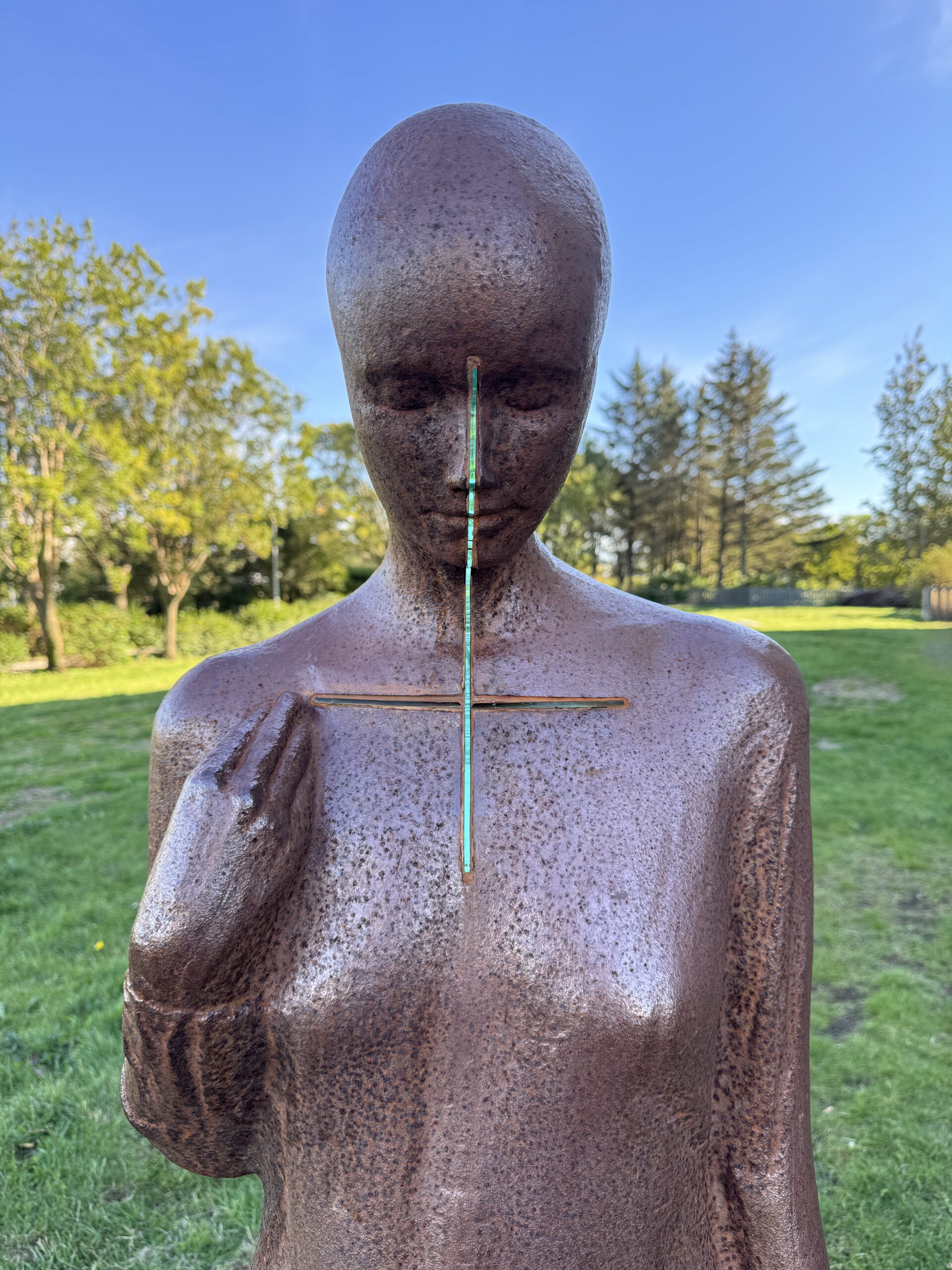
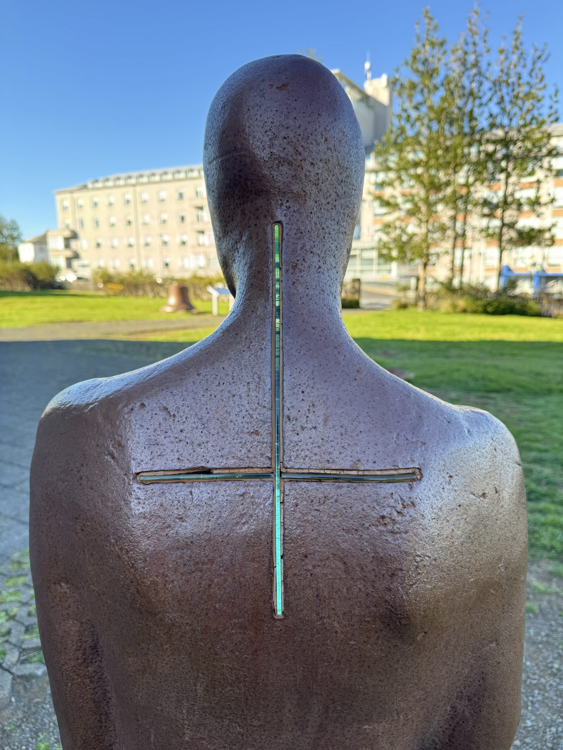
I went searching for a sculpture today, which I saw when I first visited Reykjavík in 2016 but didn’t remember where it was located. I found it outside the Catholic Church in Landakotstún. It’s titled “Köllun,” which seems to translate to either “Calling” or “Vocation” and was made by Steinunn Thorarinsdottir in honor of Icelandic nuns. I love the way the glass lets the light shine through; the artist said she “strived to have the work be gentle and quiet” and I think she was really successful.
Her website includes examples of other sculptures that make use of similar glass inlay techniques, such as this stunning example.
Noted & Done
Finished reading How Infrastructure Works: Inside the Systems That Shape Our World by Deb Chachra. Yes, this means I’m finding time to read outside of my grad school workload, and yes again that when choosing to read a book for pleasure, I picked one about infrastructure. Highly recommended! Engaging throughout and Deb is a really great writer.
Finished reading The World of the Cold War: 1945-1991 by Vladislav Zubok, which was assigned for my class “Iceland‘s Foreign Relations.” It came out earlier this year and the author brings an interesting perspective having spent 30 years in the USSR, and now 30 years in the West. A good refresher for me, especially on the earlier decades that weren’t as top of mind.
Watched Mission: Impossible – The Final Reckoning, which you know, is what it is. I like a good non-stop action movie from time-to-time, but while I can overlook the lack of believability in technology and physical feats, I’m more of a stickler for geography. There’s no spoilers in telling you that a key scene takes place on St. Matthew Island in Alaska, which is unrealistically depicted as being surrounded by thick ice that you could run a team of sled dogs on. The waters around St. Matthew don’t freeze solid like that, but luckily the folks over at Northern Journal have already written a fact checking article about it.
Attended the release party for Jack Armitage’s “Strengjavera” at Mengi. The music was made using a Magnetic Resonator Piano (MRP), and is compiled from recordings of his installation at Nordic House in 2023. Apparently he also used an MRP in collaboration with composer Atli Örvarsson on the soundtrack for the Apple TV+ show Silo.
The Love That Remains will be Iceland’s submission to the Academy Awards. It’s Hlynur Pálmason’s third time having a movie selected for the awards (previously A White, White Day and Godland) so finger’s crossed that this is his year.
This is the first week where I wasn’t sure if I’d have time to write an update. It’s 9pm on a Sunday and I’ve been doing school work for the last 12 hours. Whew! Grad school is no joke. Of course the last week has been more than just starting some classes. It’s an entirely new field, with different assumptions of pre-existing knowledge, and a structure that might be typical but differs from what I’ve experienced before. It’s been a lot, but good, and I’m sure that as things keep rolling it’ll quickly become familiar.
One small snag is that I had to swap one of my courses. My program requires either ASK105F Iceland in the International System or ASK103F Iceland‘s Foreign Relations and while I didn’t have a strong preference I chose the former because the scope seemed broader. But when the class started we found out there was a scheduling error, and its actually longer than the published timetable, which means it conflicts with one of my other classes. So I switched to ASK103F, which actually smooths out my week a bit, making my heavier 2-class days Monday/Thursday instead of Wed/Thursday.
One of the things I was curious about is whether or not I’d be an outlier in this program, given my age and background. That question was answered immediately when I met the person sitting in front of me during my first class. He’s 8 years older than me, with a background in air traffic control, and is currently a member of the Icelandic Parliament! Can you imagine a US congressperson finding themselves on a foreign affairs committee and enrolling in a graduate program to brush up on their knowledge?
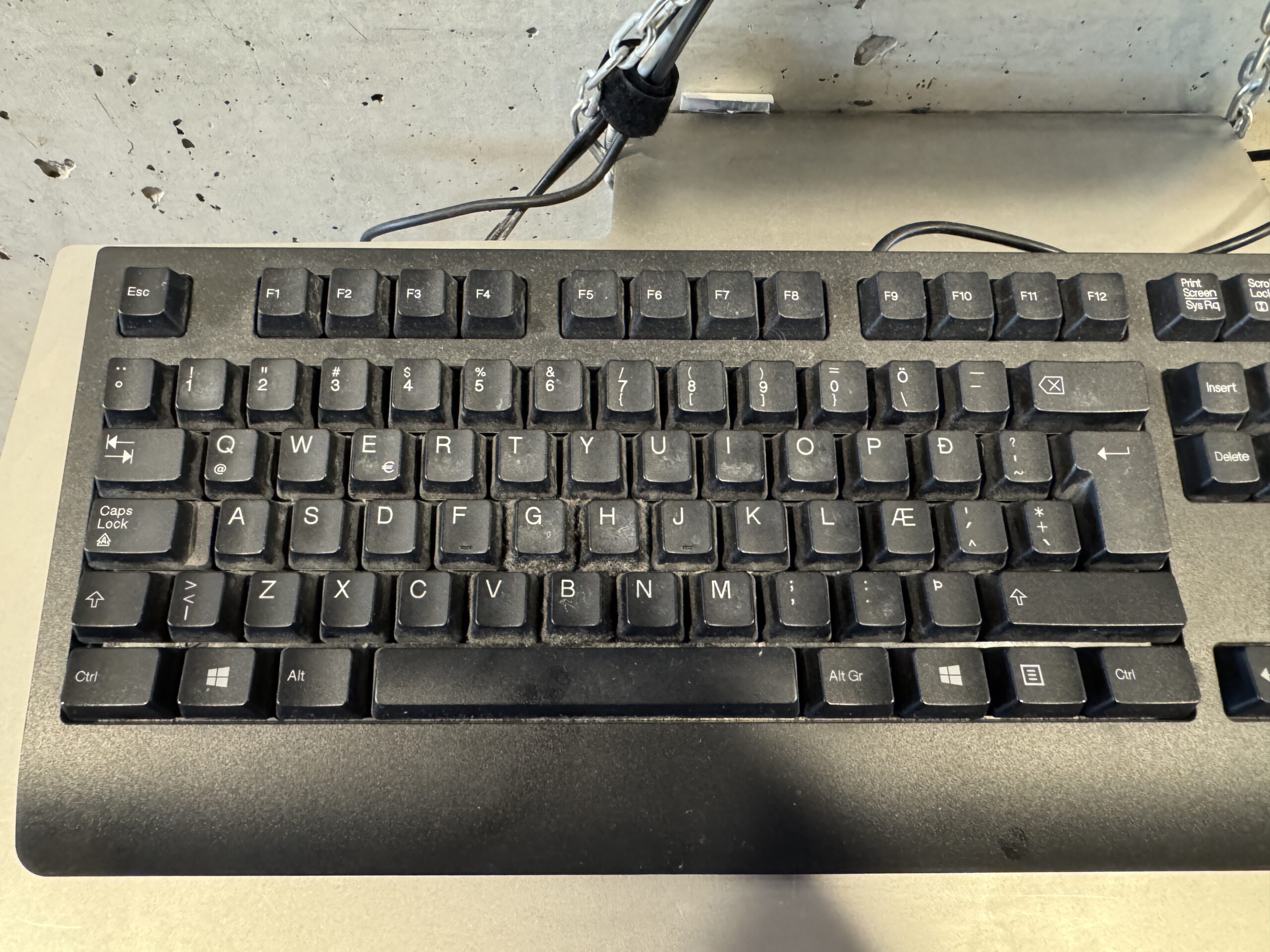
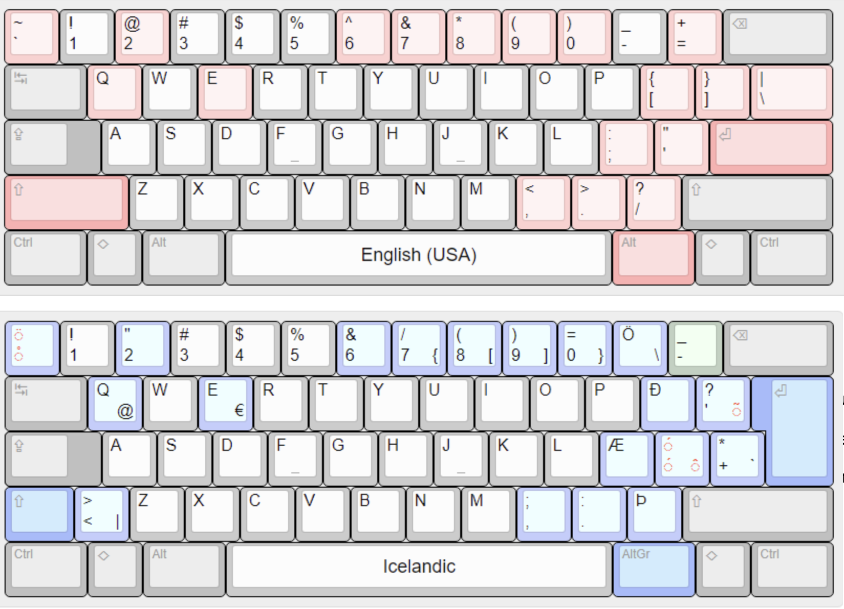
The photo above is an Icelandic keyboard, and while it looks familiar the changes to accommodate Þ, Ð, Æ, Ö, and some accent marks make it impossible for me touch type with confidence. I have to use this keyboard to print from the campus computer lab because the printers won’t connect to a laptop. Entering my username and password for the first took a few minutes. The @ symbol that is paired with the Q requires pressing the AltGr button to the right of the spacebar. And when my fingers reach for the left shift key they naturally land on the combined less-than/greater-than key, providing a nice row of >>>>>>>>>>s in the middle of your password. Some of these shifts are subtle enough to make you question your sanity, like pairing & with the number 6 instead of 7.
A visual comparison of the differences between the US and Icelandic keyboards.
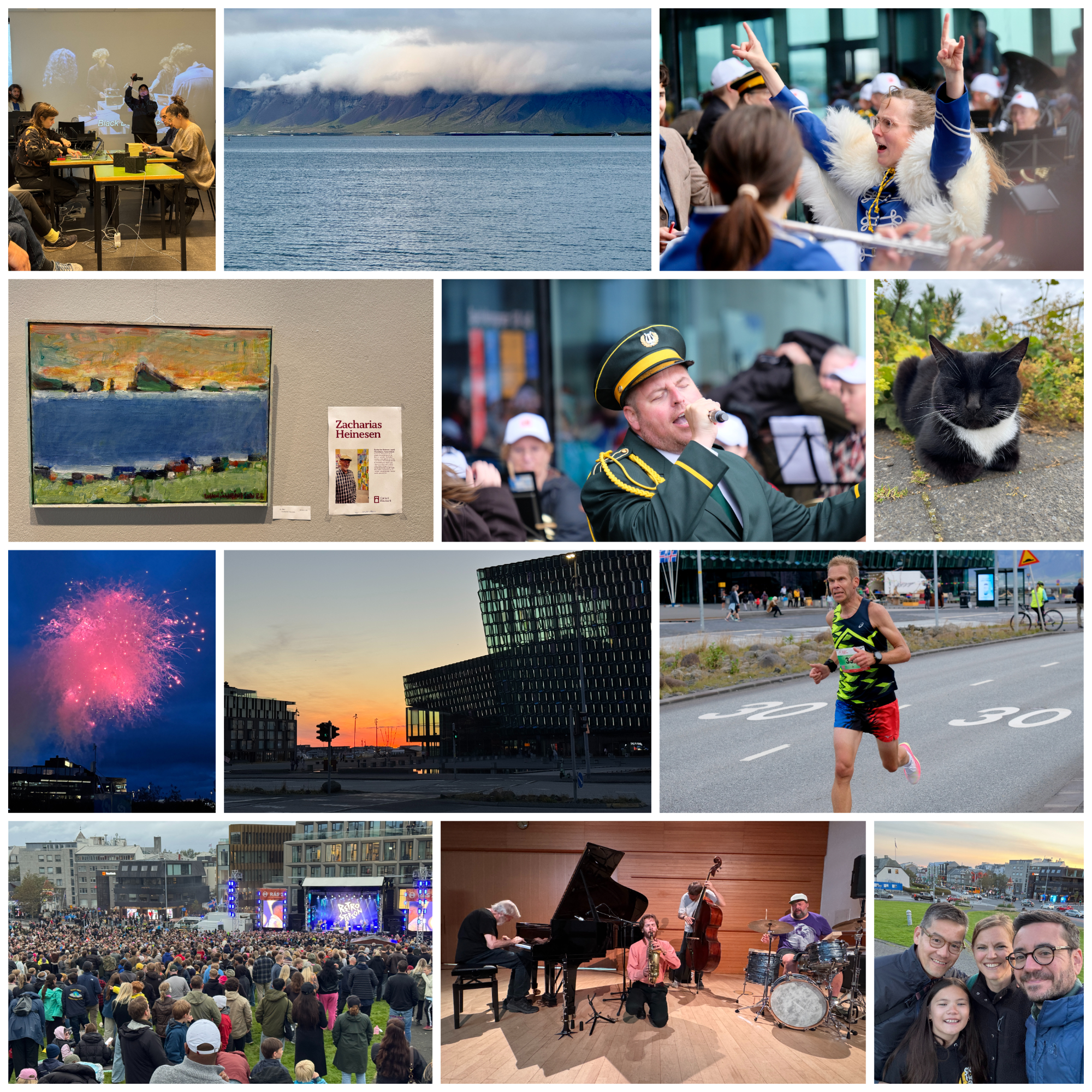
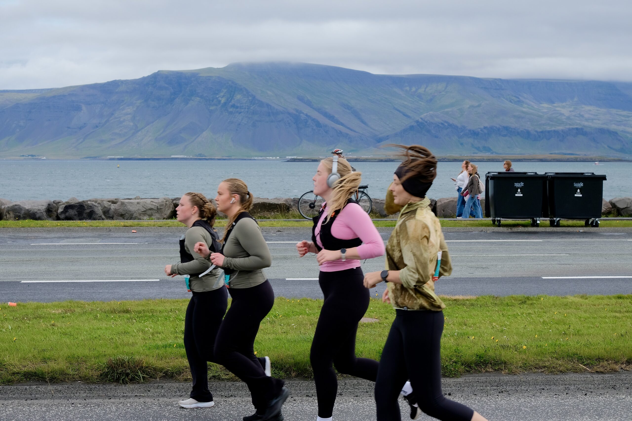
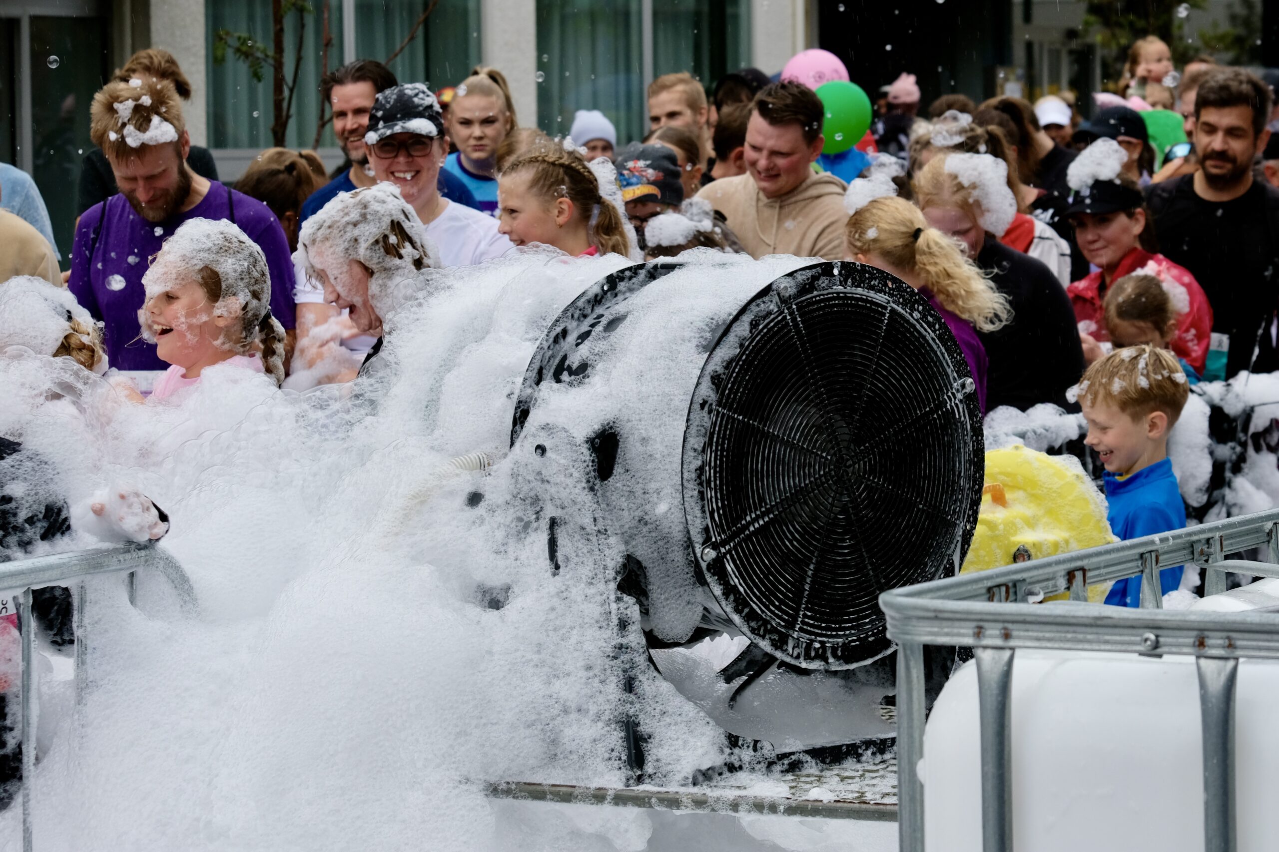
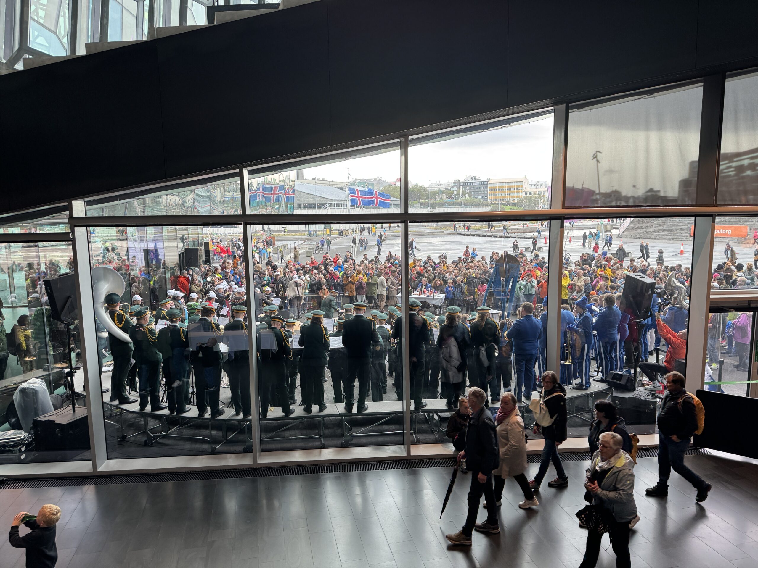
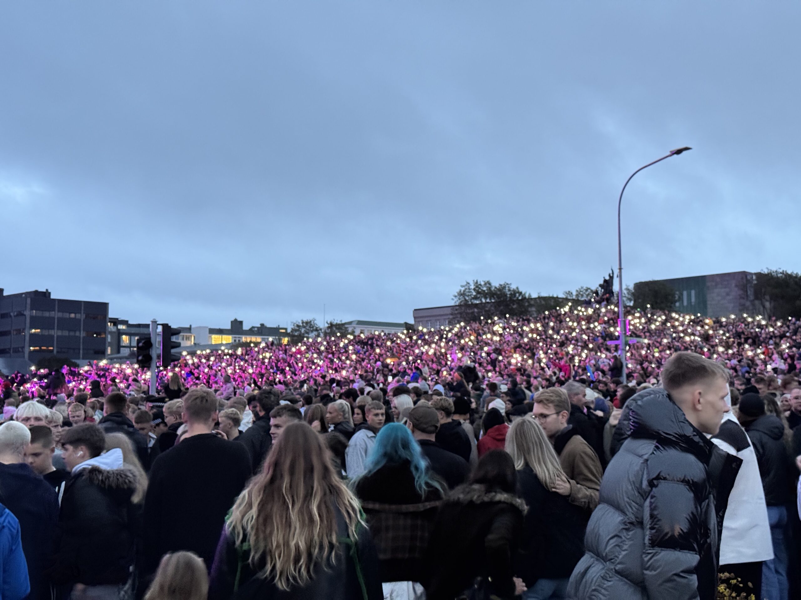
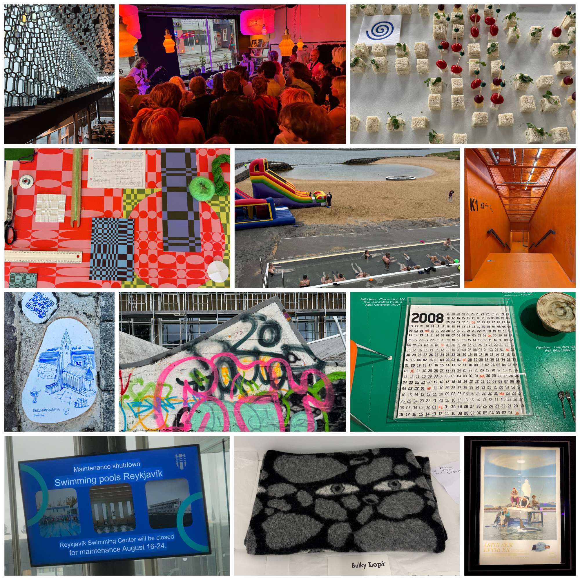
Yesterday was an hugely packed day in Reykjavík. In the morning was the marathon, and all the additional races of various lesser lengths, snaking their way through the city. By noon, events had kicked off for Culture Night, with over 400 events across the city from free museums openings, to craft markets, to live music everywhere. I had a loose schedule of things I wanted to see, but also just wandered around, stumbling into strange and delightful happenings.
Perhaps the most low-key event is Waffles and Coffee, a two-hour period where the city supplies the ingredients and materials to the host and people open up their homes to serve the eponymous items. It fosters these casual gatherings throughout the neighborhood — strangers and friends in backyards and living rooms, sharing a snack.
A Waffles and Coffee sign, welcoming people to come insideMarathon runnings in front of EsjaThe 3K fun-run had a bubble machine near the endBattle of the Bands at HarpaA sizable portion of the country gathered for a concert on the hill
Noted & Done
Had dinner with an old friend and her family before they headed out to explore Iceland on their vacation, which was really nice.
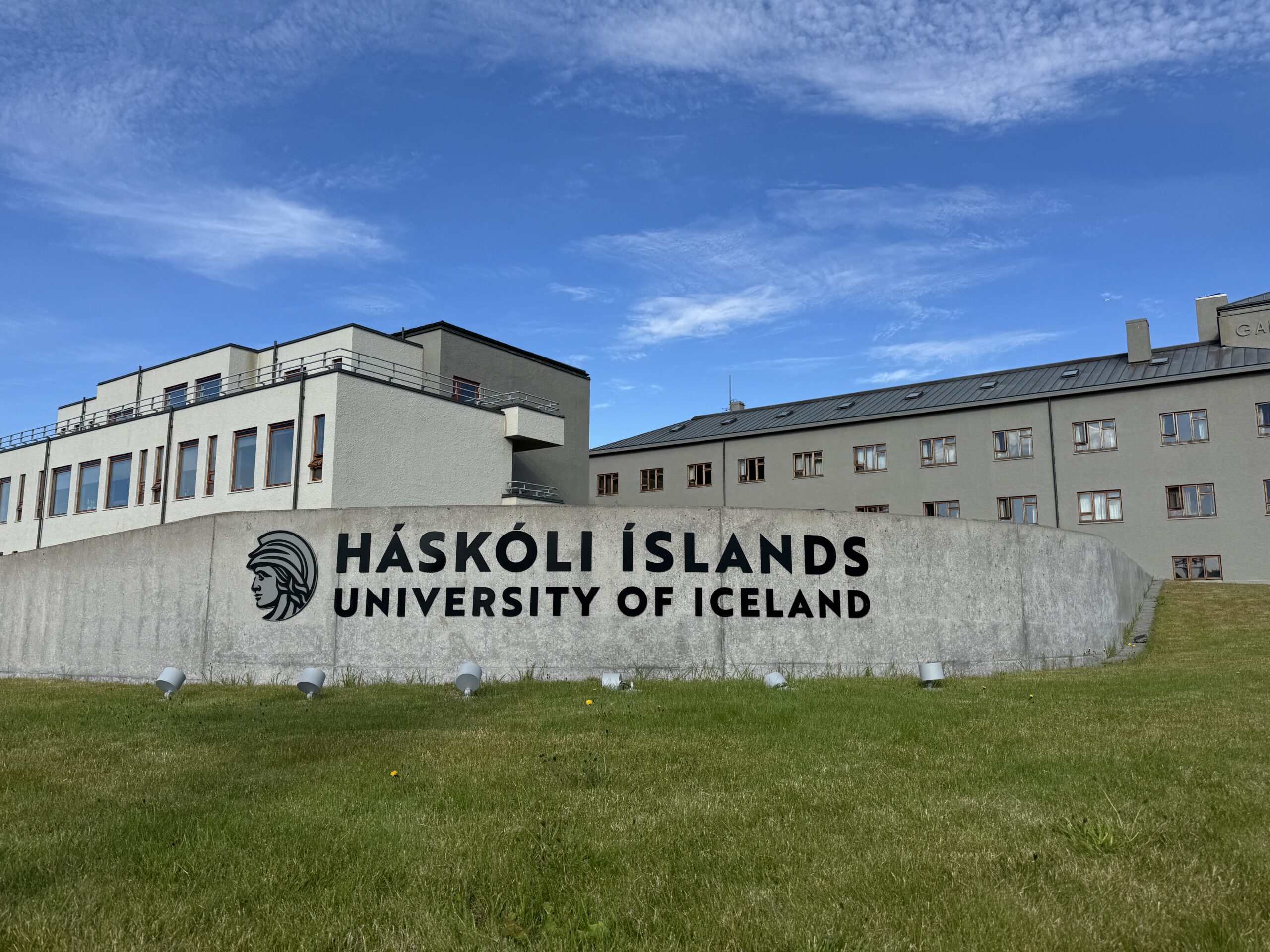
Went to the National Library for the first time, which will be a good place to study.
<rant>You know how every elevator in the USA has a “close door” button but it never does anything when you press it. Apparently this placebo button is meant to comply with the Americans With Disabilities Act, although I question that explanation since the timing of the door automatically closing is what would matter for someone with a cane or a wheelchair. Is it because Americans are so insensitive they would close the door manually in someone’s face? Also, why have a fake button — just leave it out, or put in a blank! </rant> Annnnnnyway, the elevator in my apartment here has a functioning “close door” button and it is glorious! I press my floor number, and then the close button, and I’m off.
After three weeks of various adventures to the countryside my step count was considerably more modest this week. I got my first haircut in Iceland, which might just complete the checklist of day-to-day life things to figure out, and I was out and about in Reykjavík, but not too far afield. I’m really glad I was able to move here with this five-week buffer before the start of the semester. I’ve seen amazing landscapes, I’m familiar with the city, and now I’m ready to start my grad program.
As a reminder, I’m enrolled in a 1-year graduate program in International Affairs, focusing on the Arctic. That focus shaped my course selection, and I’ve mapped my first semester to largely overlap the shorter micro-credential in Arctic Studies. One consequence of that is that I needed to overload: I’m currently registered for 40 ECTS instead of the typical 30. I can re-evaluate that within the first couple of weeks, but since some of the courses are mandatory I’d have to drop the ones I’m most interested in, so I’m inclined to try and make it work.
If you’re from the US, you might be scratching your head about “ECTS,” like I was when I first started looking at this program. The European Credit Transfer and Accumulation System is a standard across academia in Europe, and they’re calculated a bit differently than the US “credit” system. One ECTS is supposed to equal 25–30 hours of student workload (per semester), counting time both inside and outside the classroom. Whereas in the US, each credit maps to an hour spent in class. Most back of the envelope conversions I’ve seen claim that 2 ECTS is roughly equal to 1 US credit, but ¯\_(ツ)_/¯ — seems fuzzy.
Anyway, here’s what I’m planning to take this semester:
One note is that The Arctic Circle is sort of a mini-course centered around the Arctic Circle Assembly, held in Reykjavík October 16–18. This is the main international forum for Arctic topics, which I would be attending anyway. I’m viewing this less as a extra course and more as a way to ensure that I get the most out of the conference. Aside from that anomaly, the other six classes meet once a week for anywhere between 1.5 and 3 hours. I have classes on campus every weekday except Tuesday.
I had a moment this week when I realized I really needed to figure out an organizational system to manage all the readings I’ll be doing. I felt much better after I remembered and reinstalled Zotero, a free and open-source application which lets you organize documents, associate them with notes, and manage citations. It converts PDF highlights, syncs everything between Mac and iOS, integrates with Google Docs, and keeps track of your spot in a PDF when you switch devices. I feel dumb for not using this when I wrote my book.
If you have suggestions for other tools to help me manage my research, writing, schedule, or all-the-other-things, please send them my way. The last time I started a graduate program was 20 years ago, I’m sure things have changed a little bit.
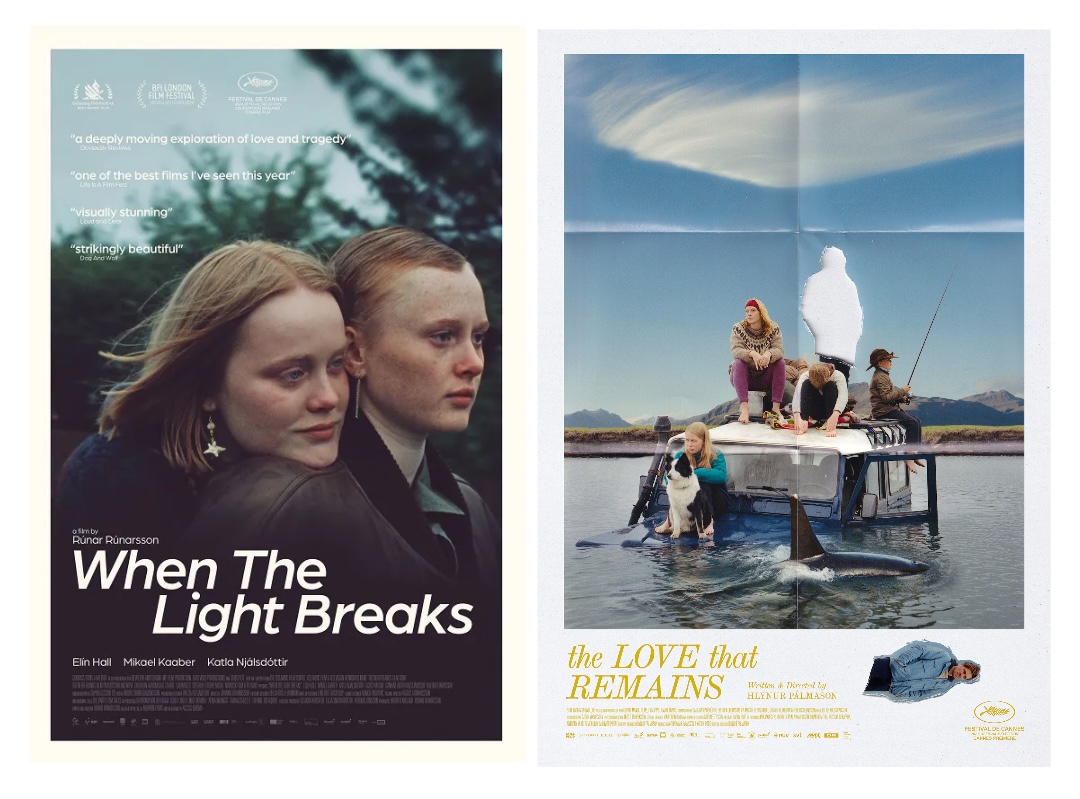
For the last decade, by shear coincidence, I’ve lived in very close walking distance to a movie theatre. In Pittsburgh the Row House Cinema was less than a block down the hill, in Minneapolis I could walk to the Edina 4 in 10 minutes, and now in Reykjavík I find myself living half a block from Bíó Paradís. What makes this latest cinema situation so great is that I’m a big fan of Icelandic films, but normally have to wait for years after their release to see them, scrounging for access in the dark corners of the Internet or subscribing to niche streaming services. But this week, given my newfound proximity and geography, I saw two recent releases that thankfully aired with English subtitles.
The first was When The Light Breaks (trailer), directed by Rúnar Rúnarsson, which came out last year. It centers on a small group of friends, two intertwined relationships, and an unexpected tragedy. It’s shot entirely in Reykjavík, much of it at the Iceland University of the Arts and Harpa, so it was fun to recognize the locations throughout.
The second film was The Love That Remains (IMDB), written and directed by Hlynur Pálmason, which was actually its Icelandic debut after premiering at Cannes in May. This is the fourth film I’ve seen by this director, and it was interesting how he incorporated a similar technique used in the 2022 short Nest to convey the passage of time. Like that film, there are shots where the camera captures an outdoor scene from a fixed point-of-view, and flashes between drastically different weather conditions that the Icelandic countryside so easily provides. Both films take place over a year, and these temporal jump cuts are interspersed with slowly unfolding scenes of everyday family and work life. He has a beautiful, simple, quiet storytelling style that showcases the story’s environments, both manmade and natural, alongside his characters’ complex relationships. There were also some metaphorical/supernatural elements, which I’m less sure about, but overall I thought it was great.
At Cannes, The Love That Remains won an award that I didn’t know existed but that I’ll be tracking from now on — The Palme Dog! More specifically this award goes to Panda, an Icelandic Sheepdog that steals scenes throughout the film. The best part is that Panda isn’t a trained actor, but the director’s longtime pet, probably not sure exactly what a film is, but always happy to be involved.
Got my first haircut in Iceland, by a Greenlandic barber. I apologized on behalf of the US, although he was convinced that nothing would come of Trump’s rhetoric of making Greenland part of America. He actually thought the attention that Greenland’s been getting could have positive outcomes. I hope he’s right.
Realized that my electric tea kettle here boils water noticeably faster than in the US. because it can pull more watts from the higher-voltage supply. Relatedly, I also realized that I need to buy a new induction charger for my electric toothbrush because my US version is only rated up to 130V. It hasn’t caught on fire yet, but I really don’t like using the word yet in the same sentence as fire.
Saw Autechre perform at Harpa, in complete darkness. Honestly, the darkness and the unrelenting aural assault that is their live show was a bit overwhelming and claustrophobic. I think that a seated venue would have made it easier to take in.
Went to RVK Poetics at Mengi, a recurring reading event. Over half were in English, so worth checking out again.
Went to an event at Hönnunarsafn Íslands, the Museum of Design and Applied Art. Small but interesting collection of Icelandic designs across a variety of mediums.
Went to the Nauthólsvík Geothermal Beach, which I learned is not one of the places my pool pass works, but cold plunging in the ocean is fun.
Did my first “vibe coding” with ChatGPT to create a script that scrapes concerts from Setlist.is and creates an iCal file I can subscribe to in Google Calendar. It works, took less than an hour total, and I wrote zero lines of codes.
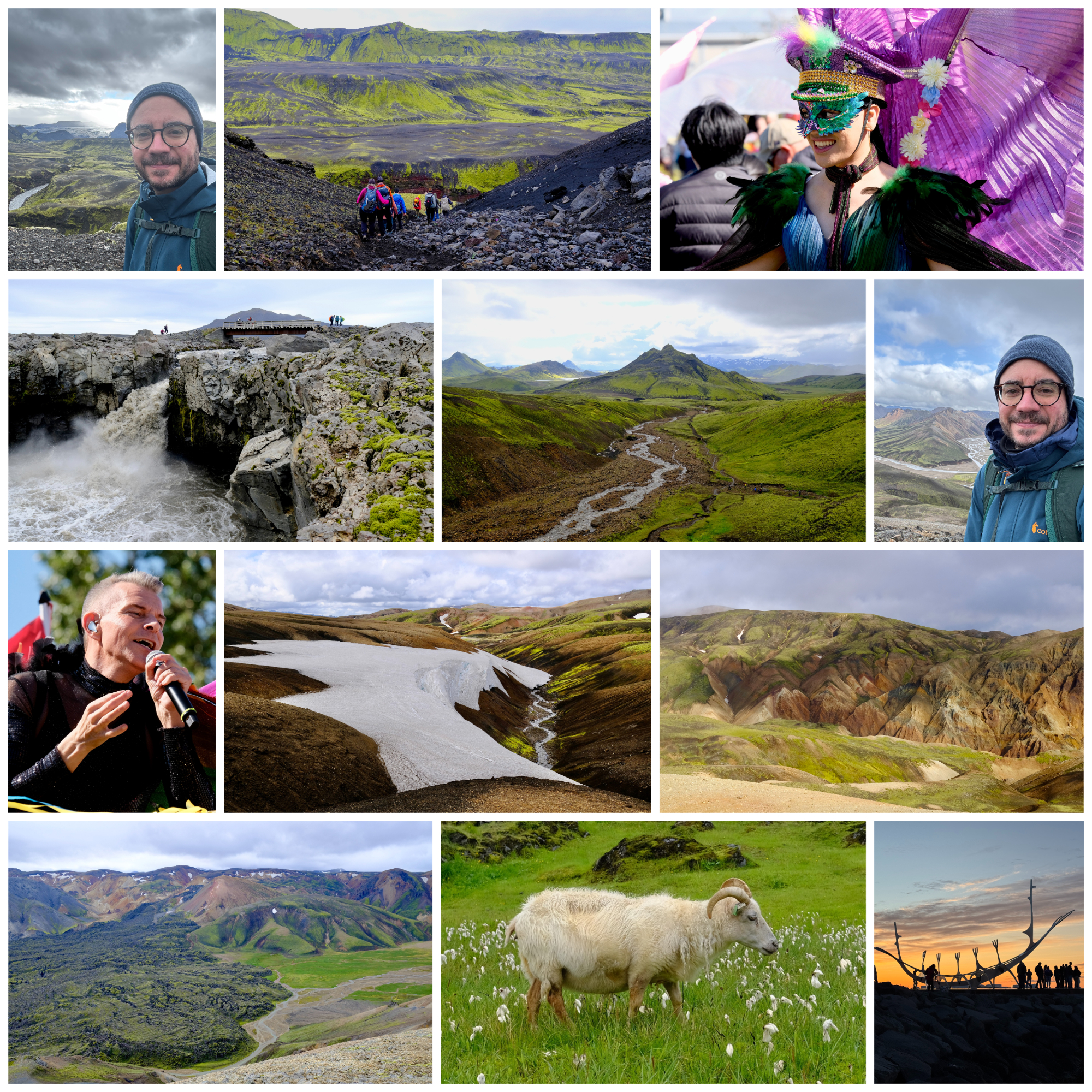
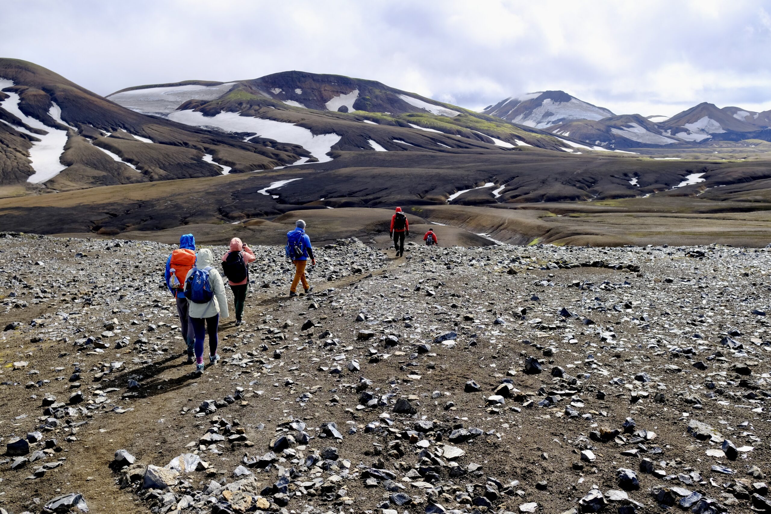
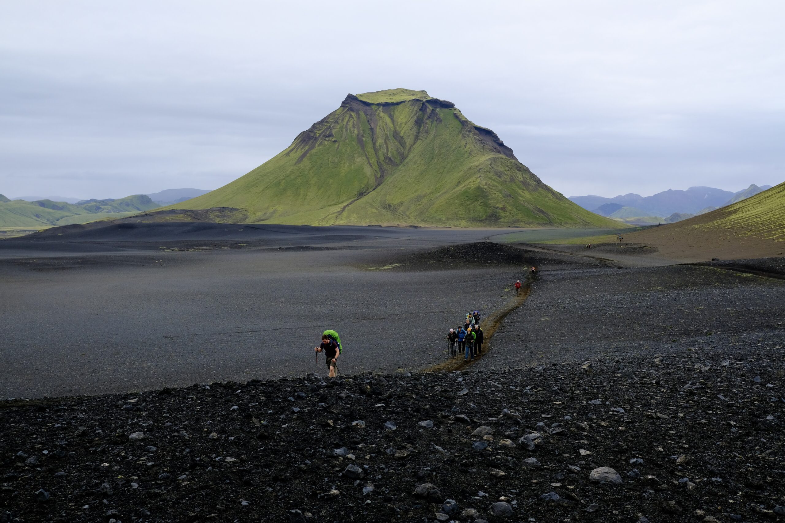
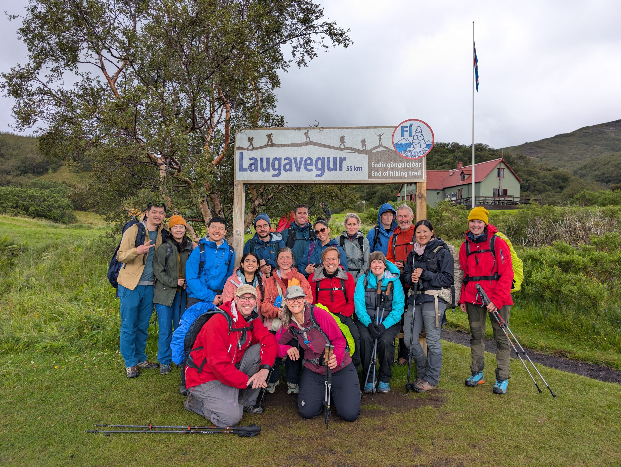
More than half of last week was spent outside, hiking in the Highlands between Landmannalaugar and Thórsmörk on the Laugavegur trail. I’ve had my eye on this trek for a long time, and it lived up to all my expectations. I went with a guided group, 16 of us in total, and hiked 40 miles over 4 days, traversing 6,000 feet of elevation gain across wildly different landscapes. It was often cold, windy, and rainy, but with fabulous views, otherworldly scenes, and a chance to have my morning coffee at the foot of a glacier — an excellent mix of Type 1 and Type 2 fun.
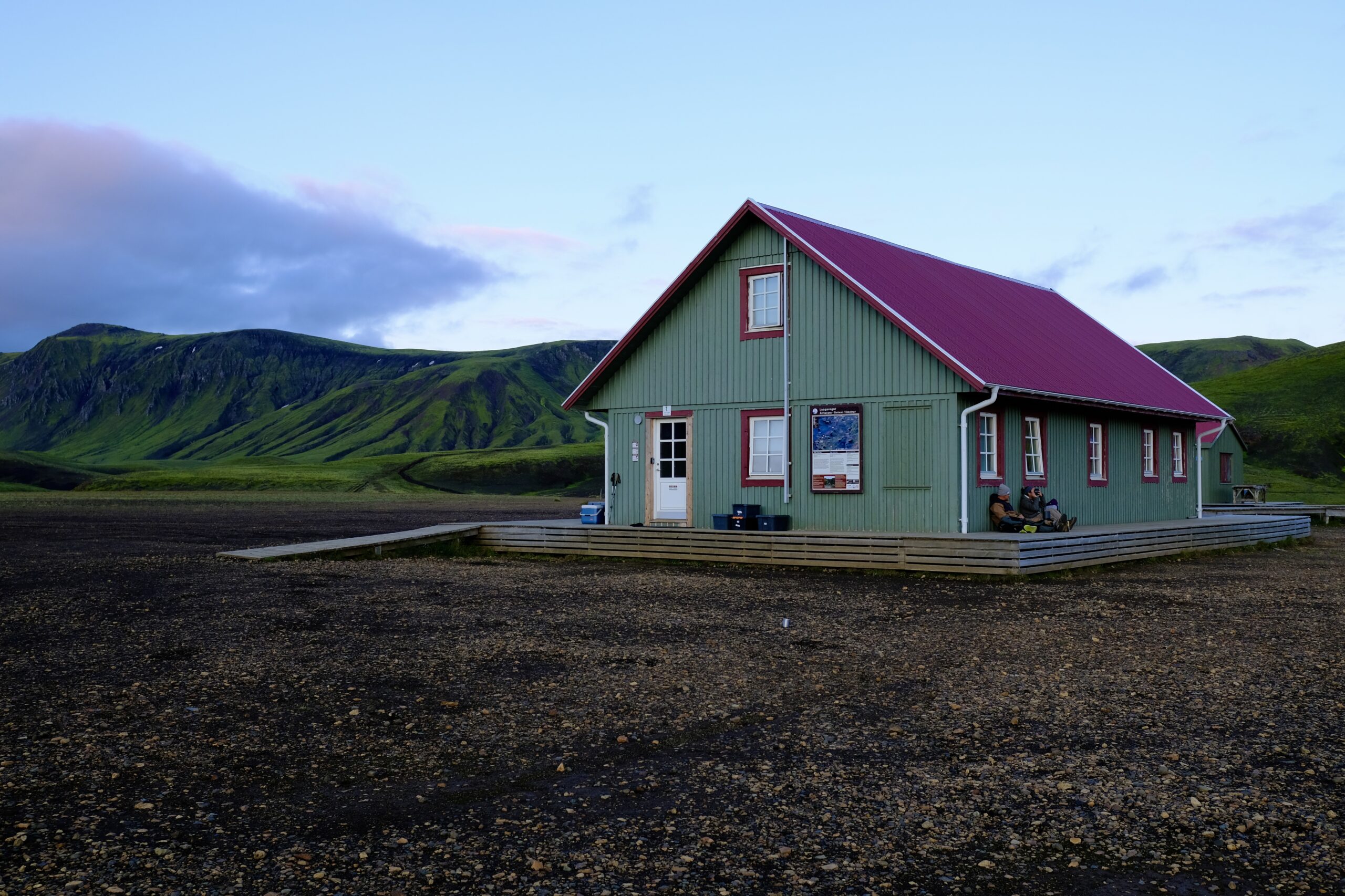
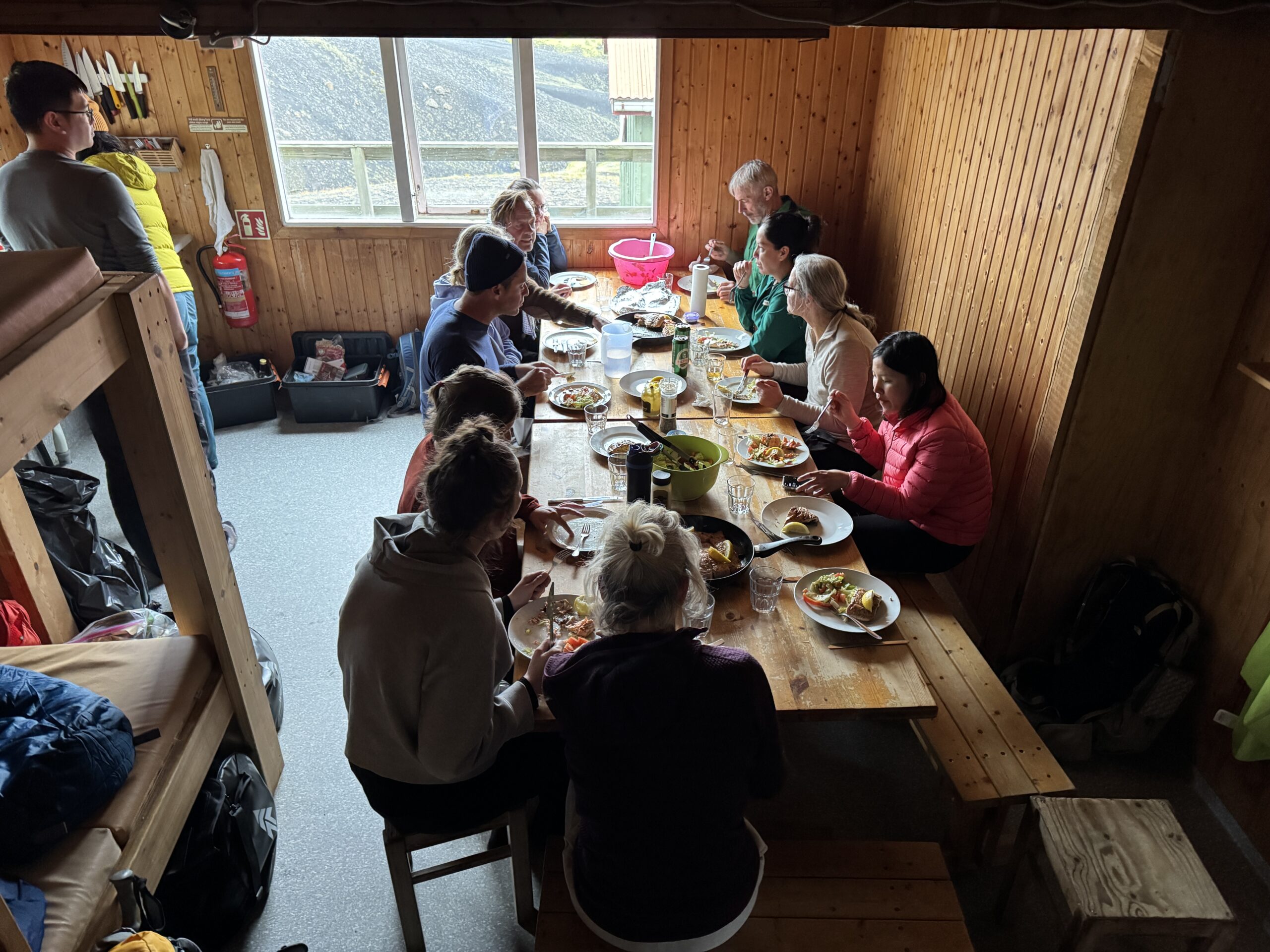
Going with a group has distinct benefits, particularly as a solo traveler. For one, I had someone to talk to, and our guide turned out to be wonderfully low-key and happy to answer all my questions. It also meant that I only had to carry a daypack, as the company transported our other bags as well as food. We stayed in mountain huts, originally constructed in the 1970s by a hiking club, which are simple structures filled to the brim with sleeping mats and a kitchen. Lots of people stay in tents as well, and there are shared bathroom facilities for everyone. For 1,000 ISK you can buy 5 minutes of hot shower time. Overall, accommodations are basic, but having tubs of food for our group transported by vehicle meant meals could be a couple notches above backpacker food.
I have photosets on Instagram for each day (Day 1, Day 2, Day 3, Day 4), so I won’t overdo it on the photos here, but below is a brief daily overview.
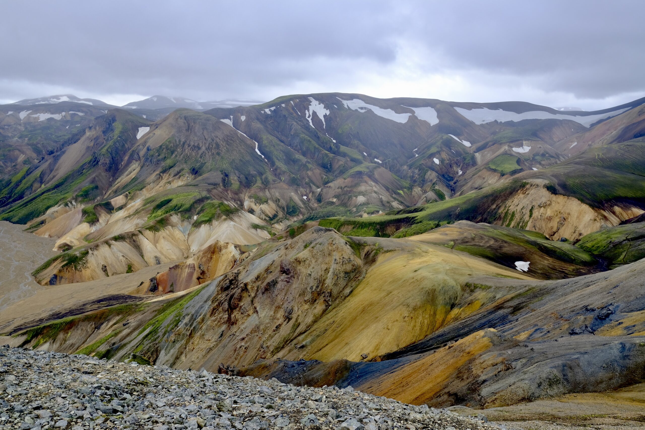
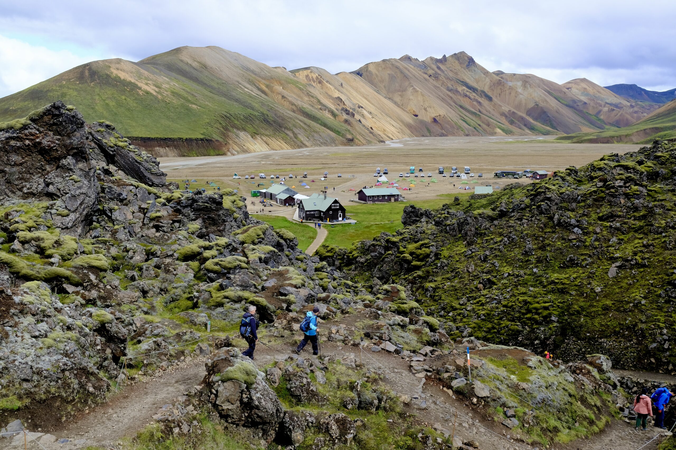
Day One: Landmannalaugar
Landscapes at LandmannalaugarLeaving the lava field at Landmannalaugar, approaching the hut and campground
The trip to Landmannalaugar from Reykjavík took about 3.5 hours, which would make it possible to do as a very long day-trip. We didn’t actually start on the Laugavegur Trail this first day, but did a four-hour hike through the colorful landscapes and lava fields of the area. It was the windiest of all the days, and threatened to downpour as it had the the day before. But the rain remained scattered, with patches of blue sky, and it was a great introduction to the trip.
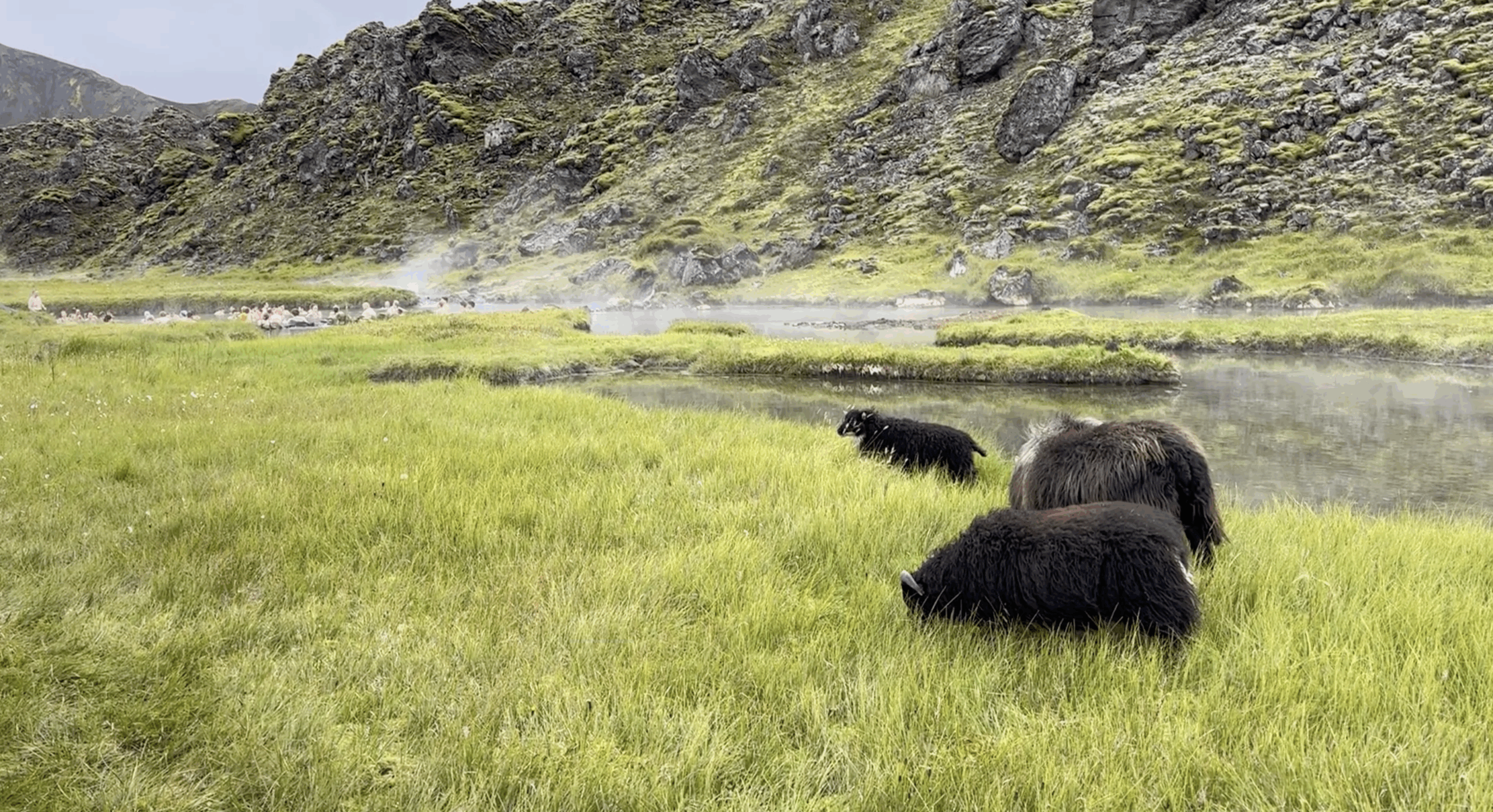
We stayed in the hut in the center of the above photo, the only one on the trip with hot water on tap since this was a geothermal area. A hot spring runs in front of the hut, feeding a pool a short distance away, which felt amazing to soak in after the hike. It was my first natural hot spring in Iceland and it was fun to see how you could moderate the temperature by positioning yourself within the pool. As you moved closer to the river it got uncomfortably hot, but you could also get extra heat by digging your feet or hands into the pebble-covered ground.
A very Icelandic scene: sheep grazing with people bathing in a hot spring in the distance.
Day Two: Landmannalaugar to Álftavatn
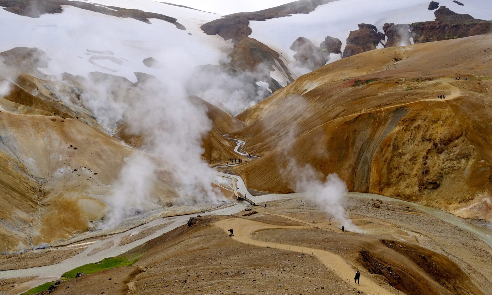
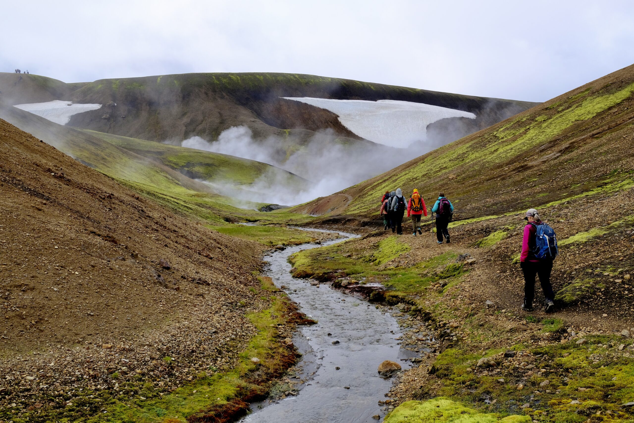
The second day was the longest, at 15 miles, and was technically two segments of the trail as we passed by the Hrafntinnusker hut halfway through. It also had the most elevation. The day started with steamy geothermal landscapes, including steam vents and mud pots, giving way to rockier and snow-covered terrain as we passed over a mountain pass. The trail only opens in mid-June, because the snow pack is too deep before then. We were continuously going up and down, as the trail runs through numerous valleys, although some were still filled with snow that bridged across them. You have to be careful as you cross those because the snow melts from both the top (sun) and bottom (hot springs), potentially obscuring the true depth of the snow you’re walking across.
Steamy hot springs provided an otherworldly feel throughout the day.The landscape became rockier and snowier mid-day.
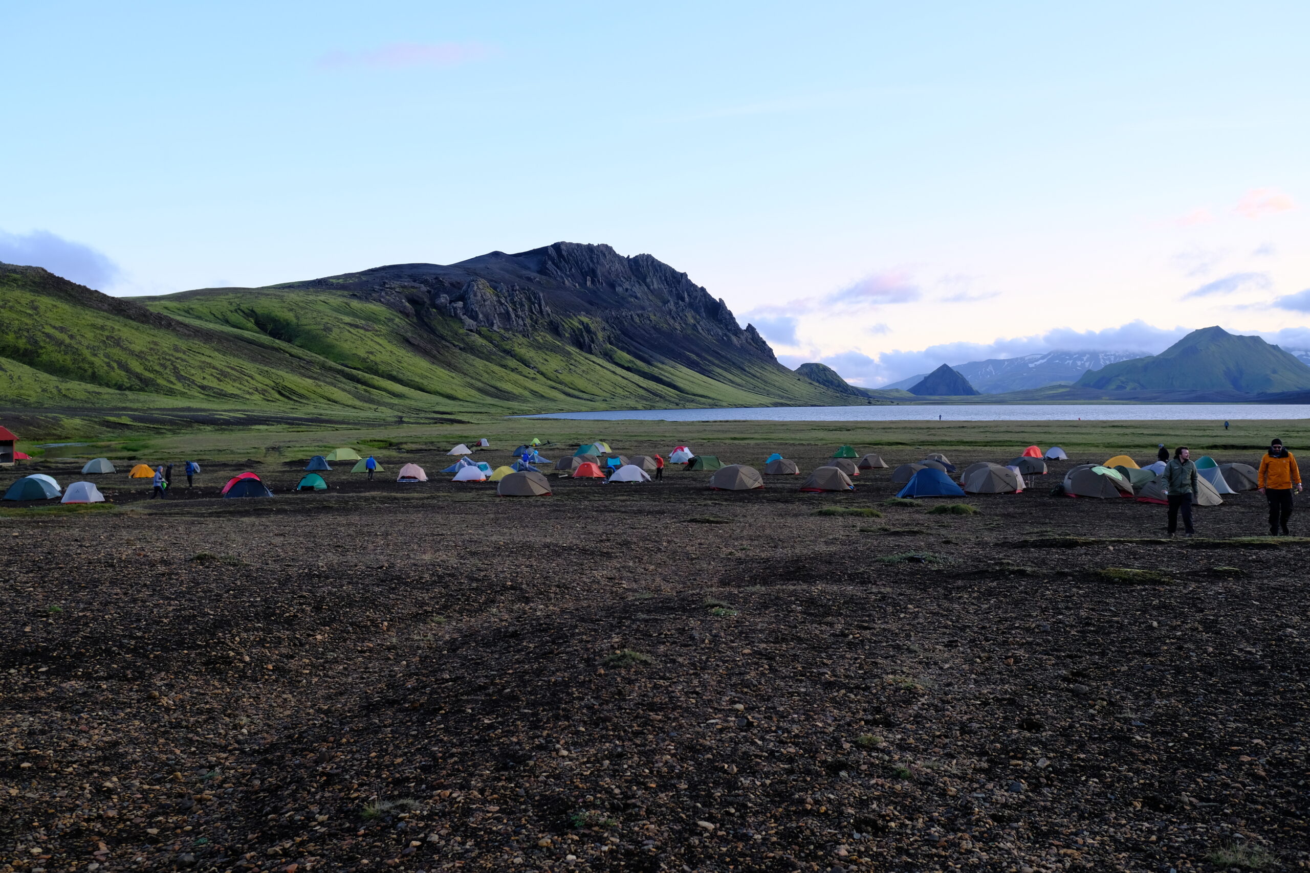
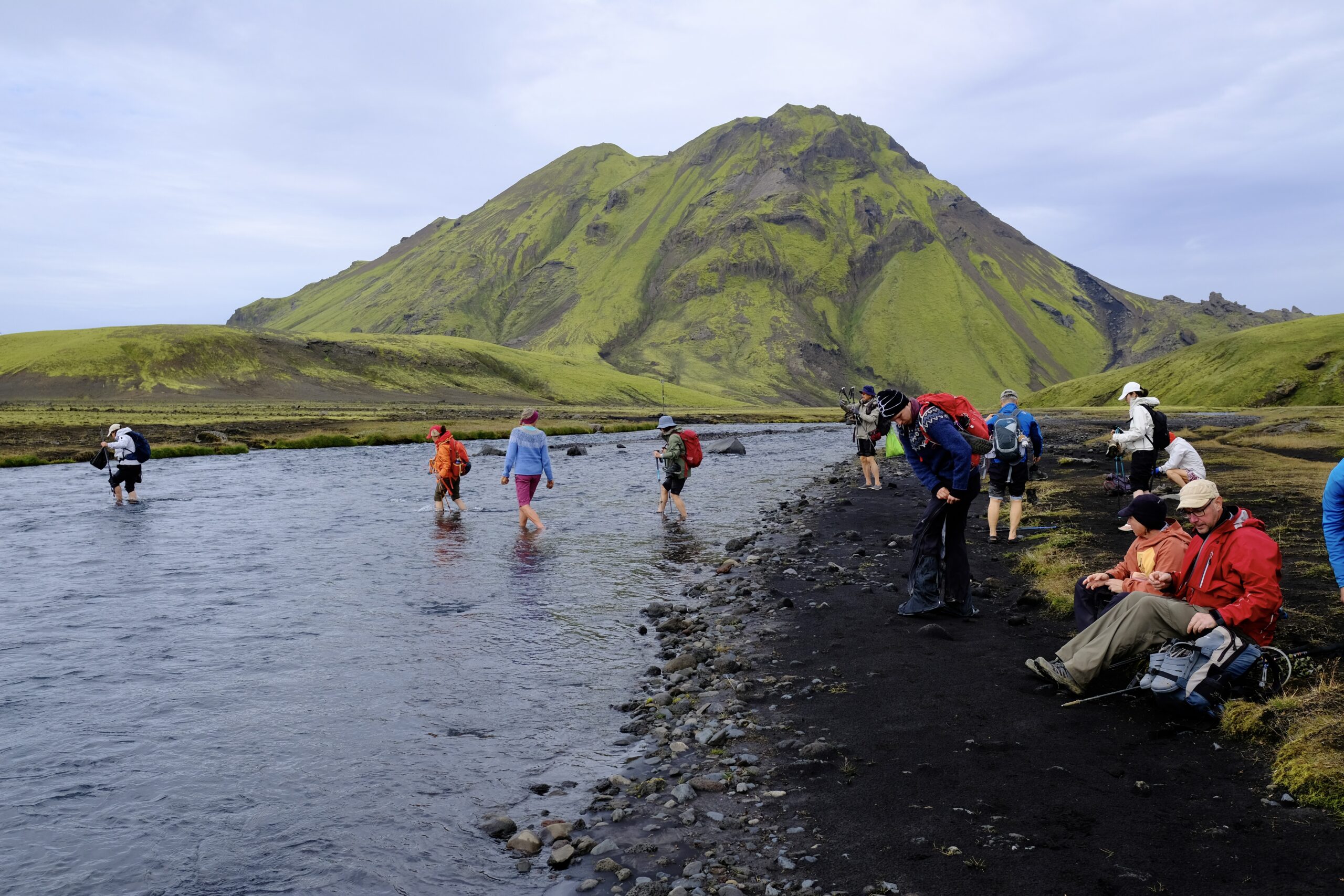
The hut at Álftavatn was the best of the trip with more spacious quarters and a generously sized kitchen, beautifully situated on the edge of a lake. The multi-hour steep downhill trek to the campground wrecked havoc on our feet, but just before arrival we had our first river crossing and the freezing cold water helped to sooth the swelling. There were four river crossings in total on this hike, and I carried an extra pair of water shoes for them. They were bone chillingly cold, but a fun part of the experience as I’d never done it before.
The hut at Álftavatn.Camping area at Álftavatn, next to the lake.
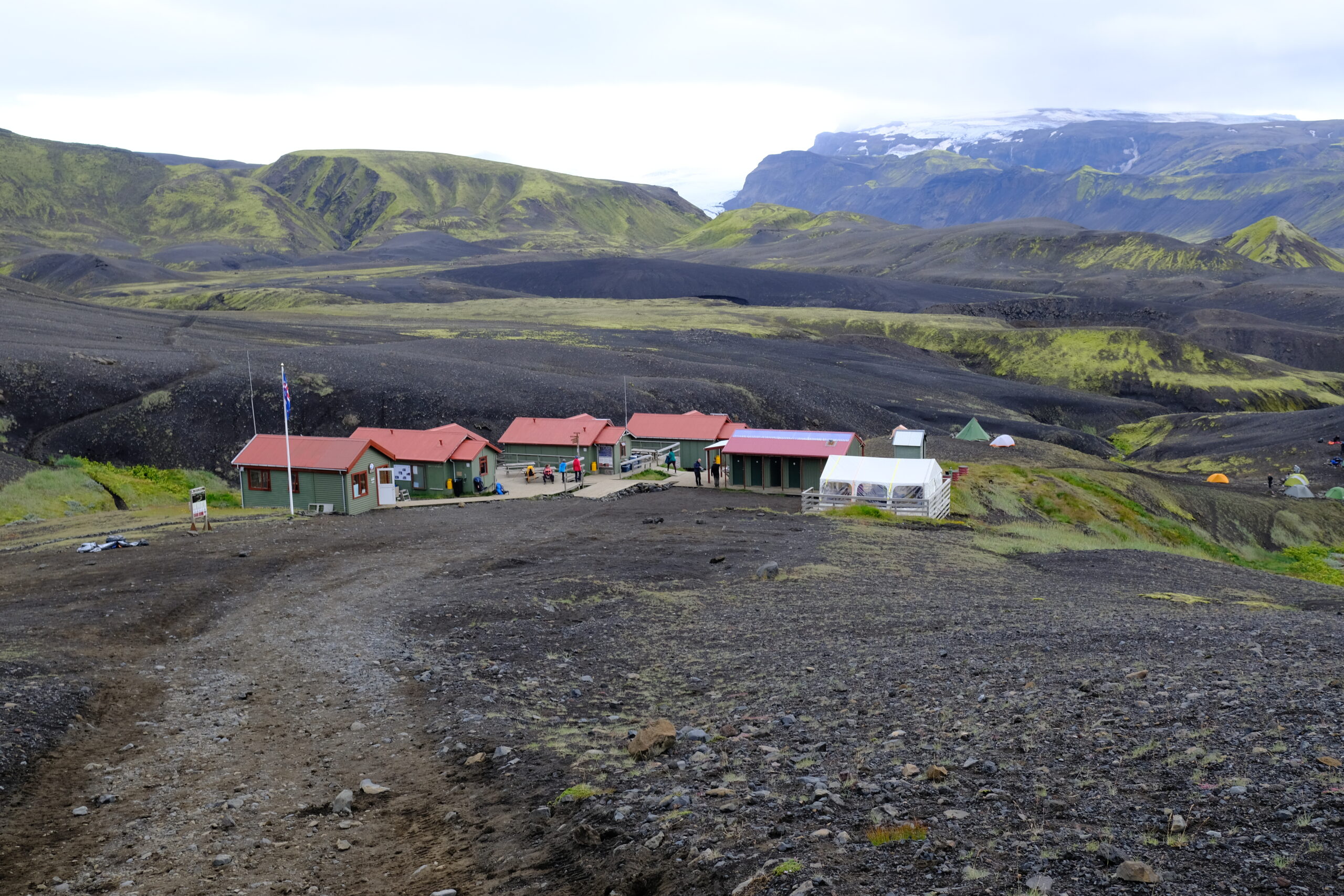
Day Three: Álftavatn to Emstrur (Botnar)
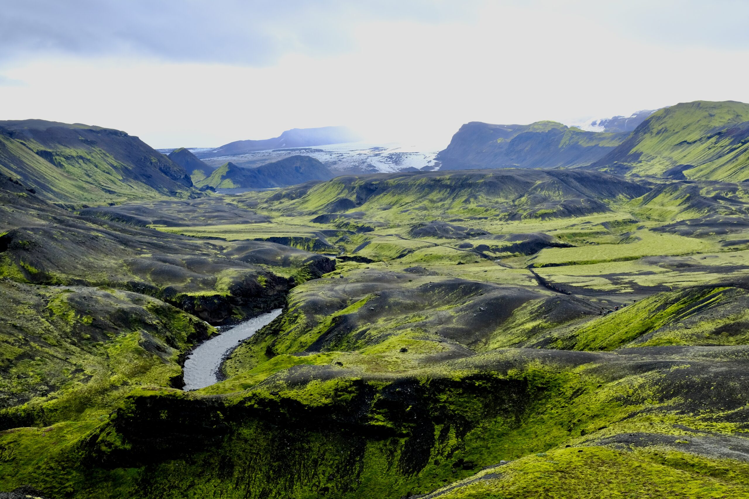
The third day saw a dramatic shift in scenery, away from the colorful geothermal hills to a stark black and green landscape. It was rockier, and much flatter than previous days. There was another river crossing less than an hour into the hike, and I think there is where I made the mistake of not fully cleaning all the tiny rocks out from between my toes after the crossing. By the end of the day I’d discovered that the smallest toe on my right foot was lacerated where it joined my foot; I think a small stone had abraded it all day as a walked. It wasn’t terrible, and better than getting a blister, but made the final day of hiking a bit uncomfortable.
River crossingMuch of the day was starkly black and green. There’s no life up there, no birds or sheep.
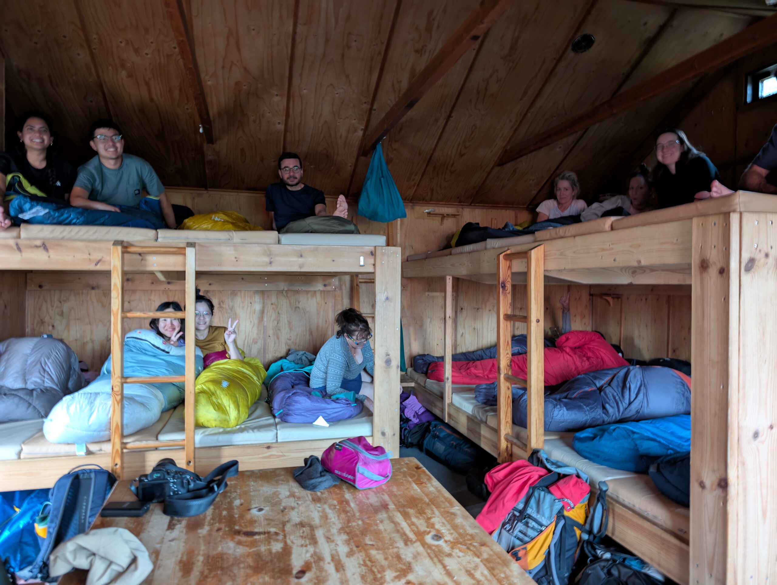
The siting of our final huts at Emstrur/Botnar was beautiful, situated in a valley next to a glacier, but they were also the most cramped. It was raining steadily when we arrived, which means the 21 people staying in tiny hut #2 were all huddled inside trying to dry off.
The Emstrur/Botnar huts.Glacial view from the hut.Packed sleeping quarters.We had to eat in shifts in this tiny hut because there wasn’t quite enough room around the tables.
Day Four: Emstrur (Botnar) to Þórsmörk
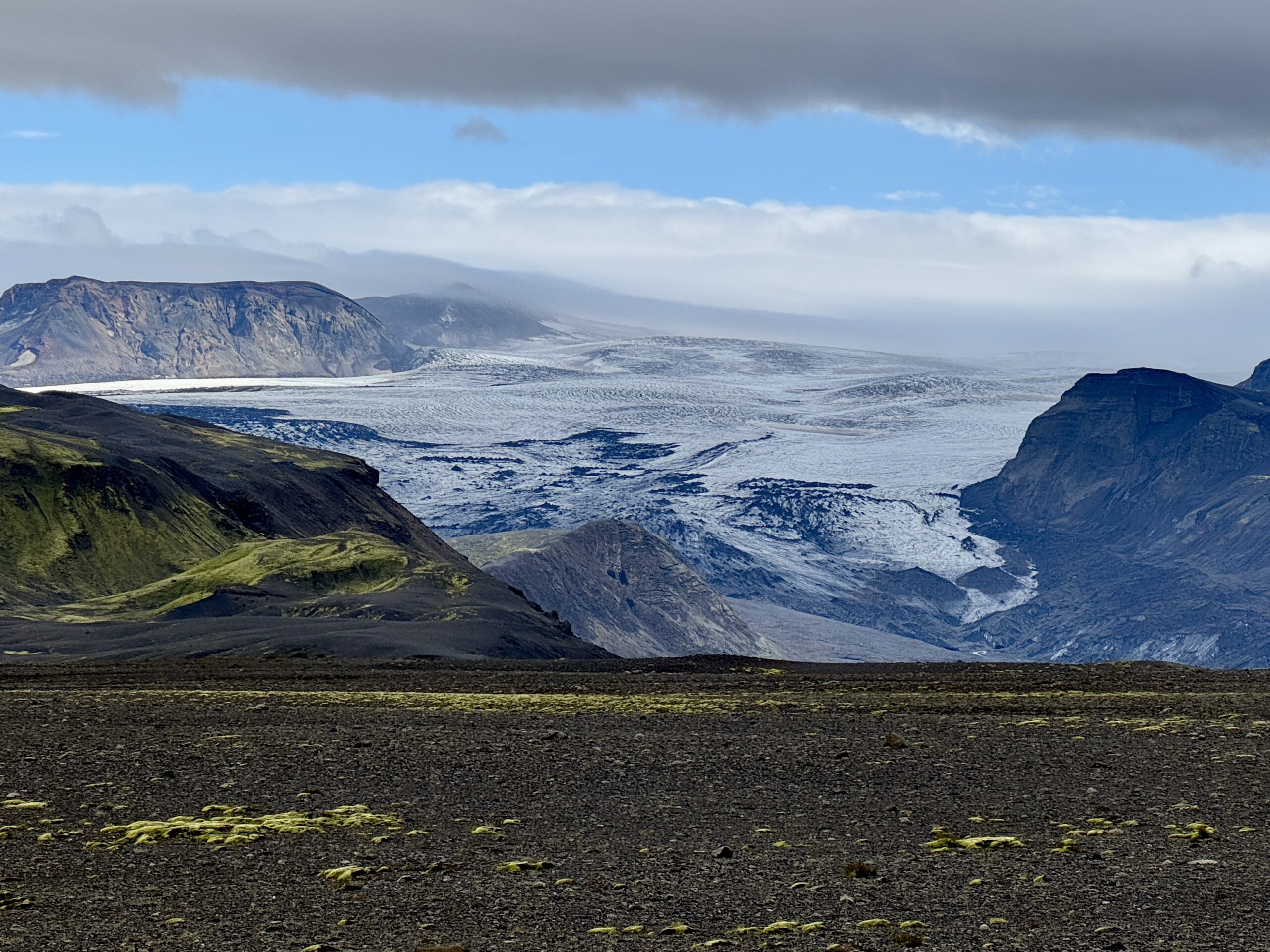
On the final day, the trail ended at Thórsmörk, one of the only native forests in Iceland. You could observe life returning as the day progressed, with a few birds flying over canyons and ewes leading their lambs around the hills. During this segment we travelled between the Mýrdalsjökull and Eyjafjallajökull glaciers, ending in a flood plain with clear views of both. Between the biggest river crossing, feeling a bit weary, and my slightly wounded foot, I ended up relying on my hiking poles more during this segment. I used them periodically throughout the trail when I felt the need for additional stability, like going down a steep and muddy decent, but there was always a tradeoff between holding my poles or my camera.
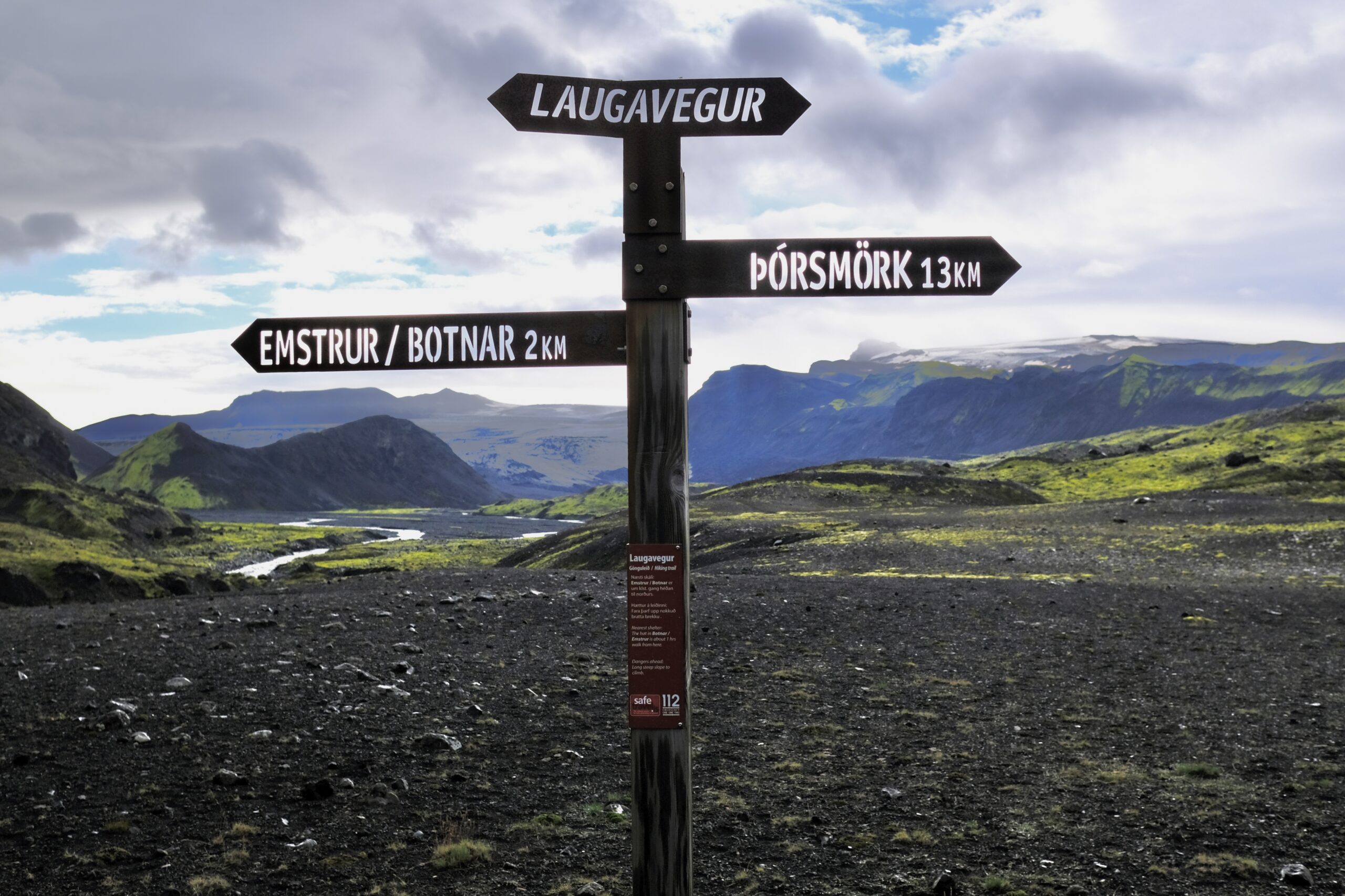
Valley with Mýrdalsjökull galcier in the background.These signs were found throughout the trail. Punching the letters out of metal is smart, as I doubt that a painted sign would last very long in this environment.My group at the end of the Laugavegur trail. We were a mix of people from the USA, Canada, Switzerland, Taiwan, and Norway.
We didn’t stay in the hut at Thórsmörk, although they did let us relax there while waiting for the bus to arrive. There are additional trails in that area that looks great, and three huts in total. Most of the people doing the full hike were foreigners, but I was told that Thórsmörk is a place that native Icelanders regularly come to recreate. I might try to make my way back here, for a day trip or a night in a hut. But the season for the Highlands is very short: basically mid-June to mid-September.
Getting back from the hike I laid low for a couple of days, catching up on sleep, laundry, and email. But I was able to register for my classes, and getting the syllabus’ and schedule provides me with a sense of the structure that I’ll have starting August 18th. I’ll share more as things get going.
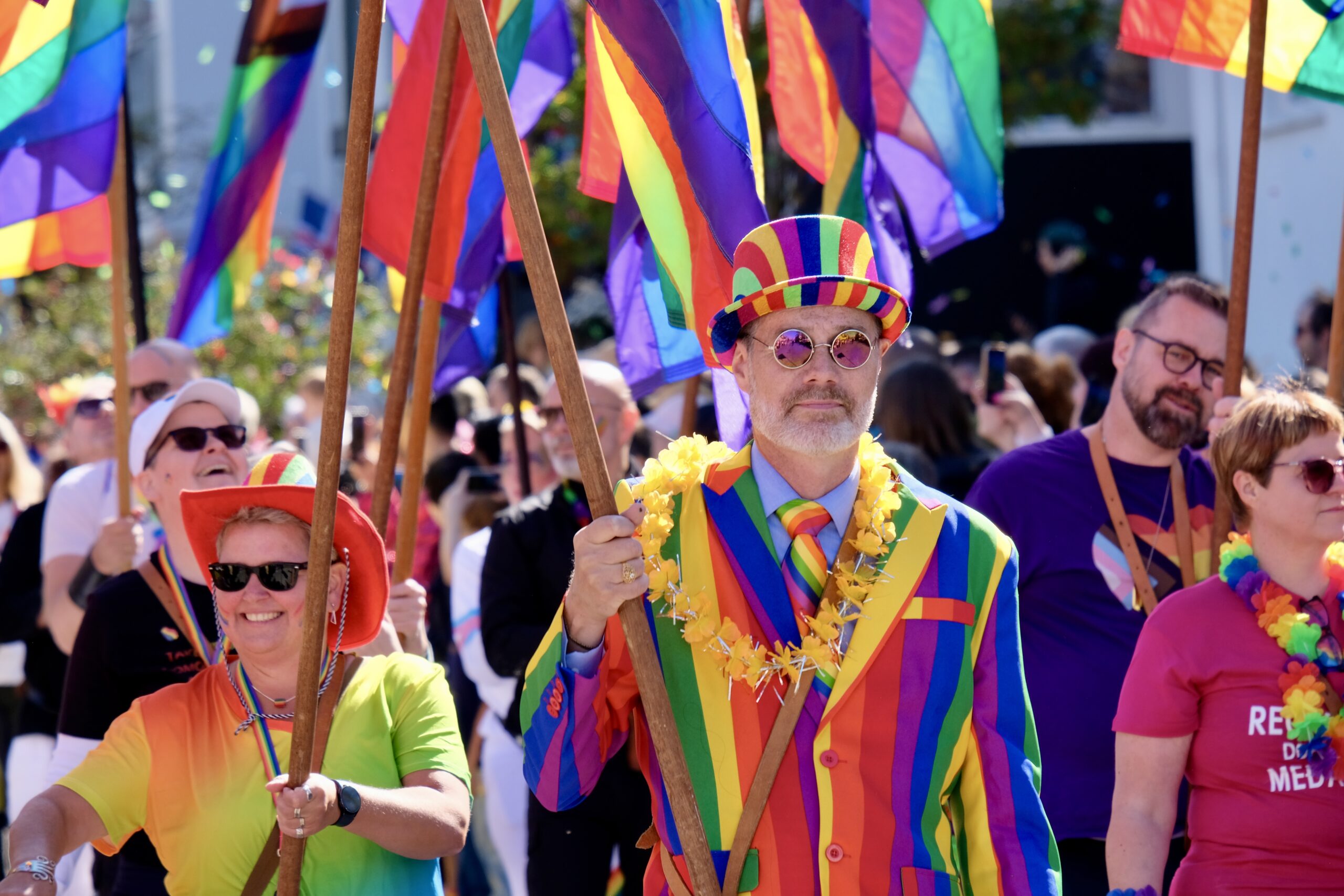
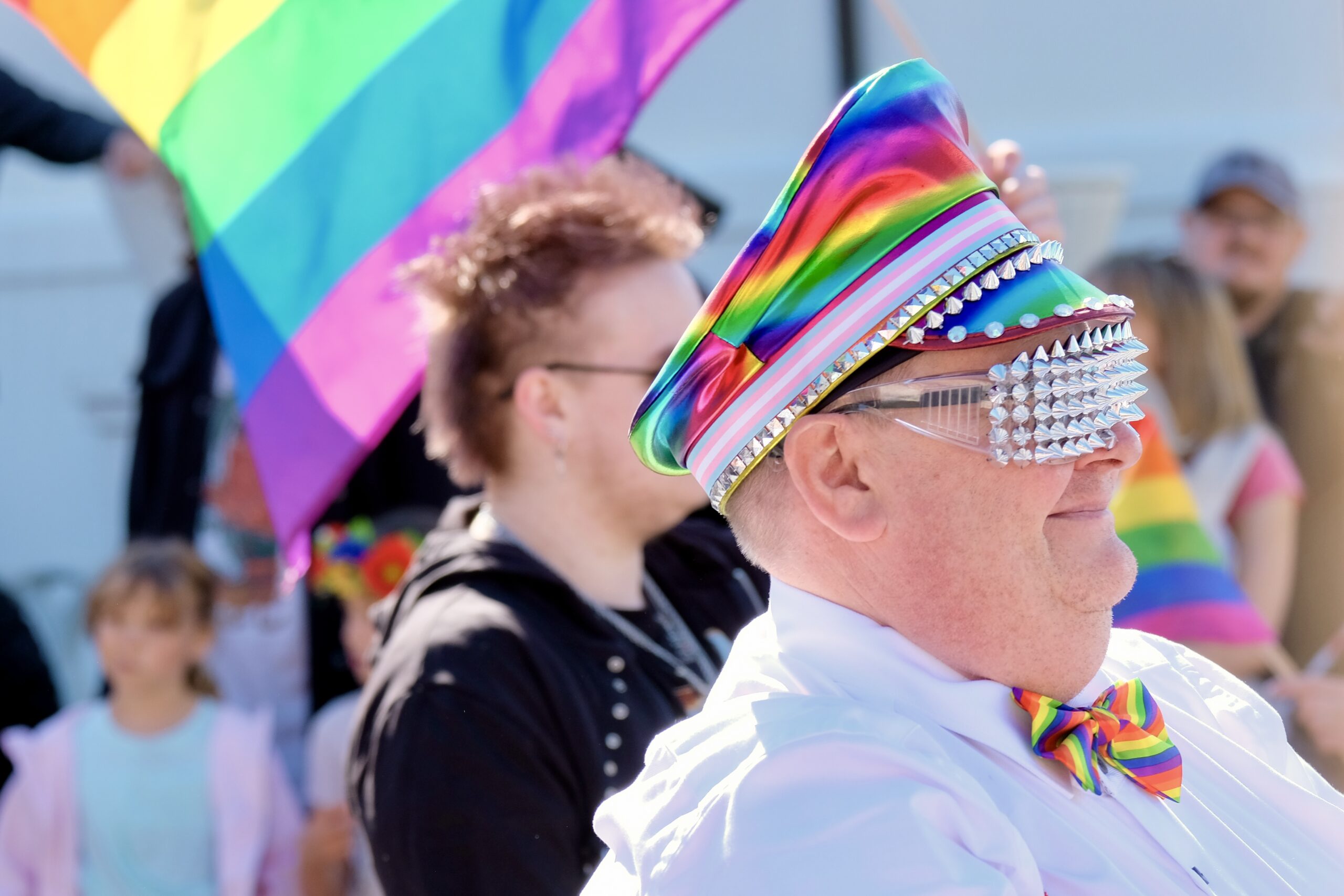
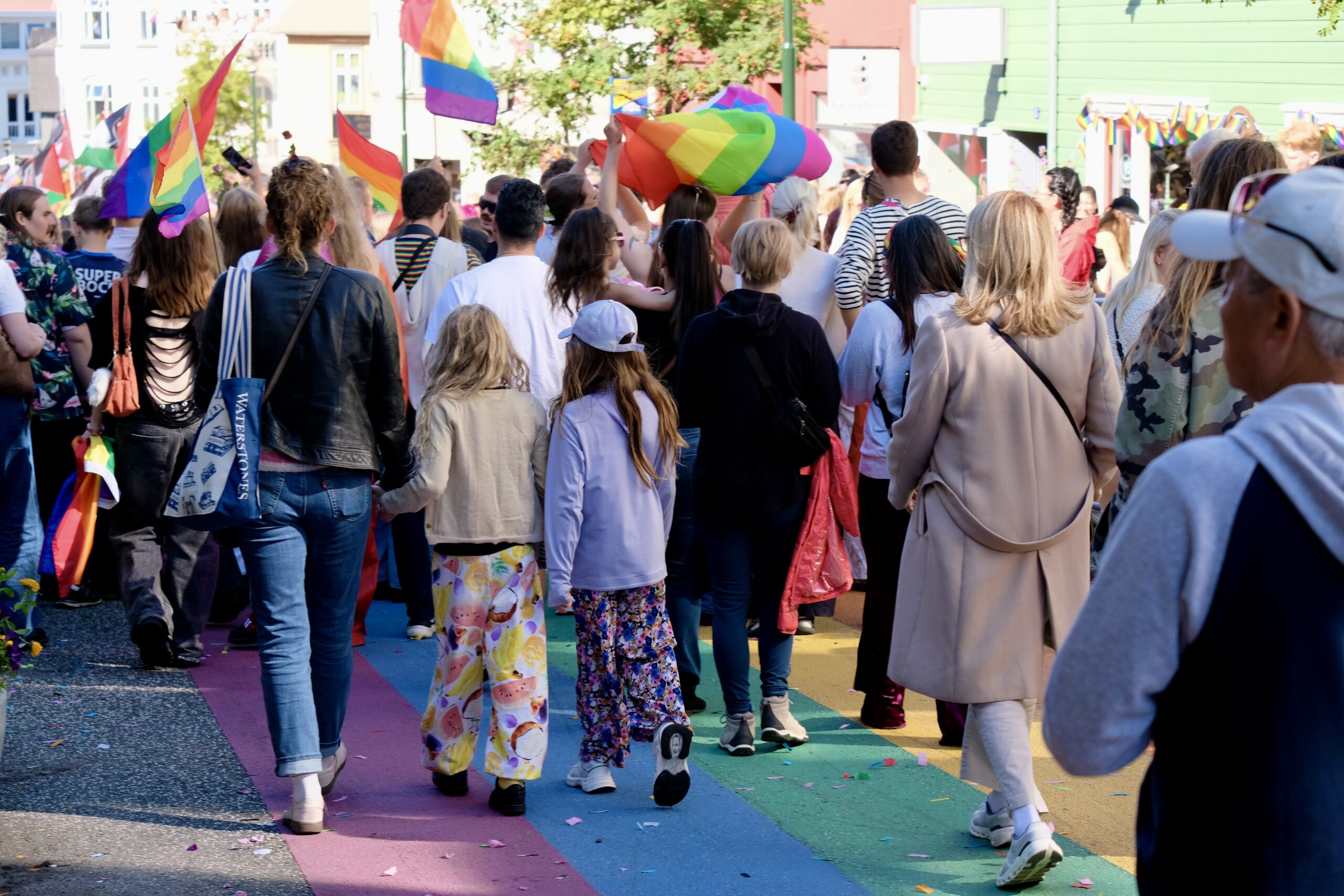
The weather in Reykjavík had been dreary all week, but yesterday in it was nearly perfect for the Pride Parade. Clear blue skies, upper 50s, and a massive celebration of diversity and equality. Perhaps the biggest difference about Pride in Iceland versus the US right now is the fact that the Prime Minister attended and spoke at the celebration.
Noted & Done
I’m noticing that the light is starting to change. When I moved here last month it felt like daylight when I went to bed, now it feels like dusk and I’m awake to see an actual sunset.
A Highland bus from TREX is bookable for a self-planned trip to Þórsmörk or Landmannalaugar. They aren’t cheap at ~$228 round-trip, but the alternative is to rent a car that can drive through deep rivers. Apparently these buses can handle up to 2 meters of water.
Registered for my classes at the University of Iceland.
Checked out Góði hirðirinn, a second-hand shop, and got some fun and random things for my apartment.
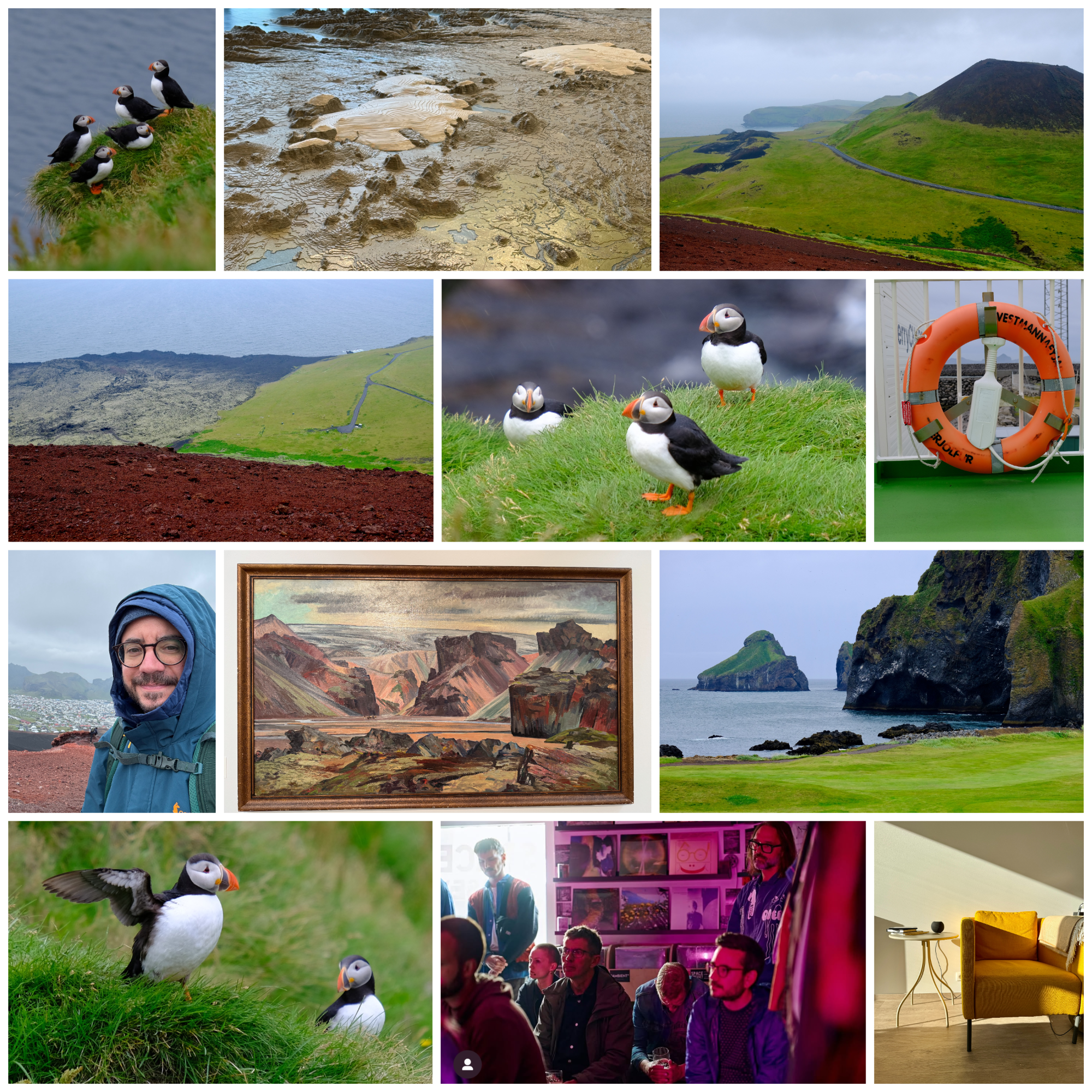
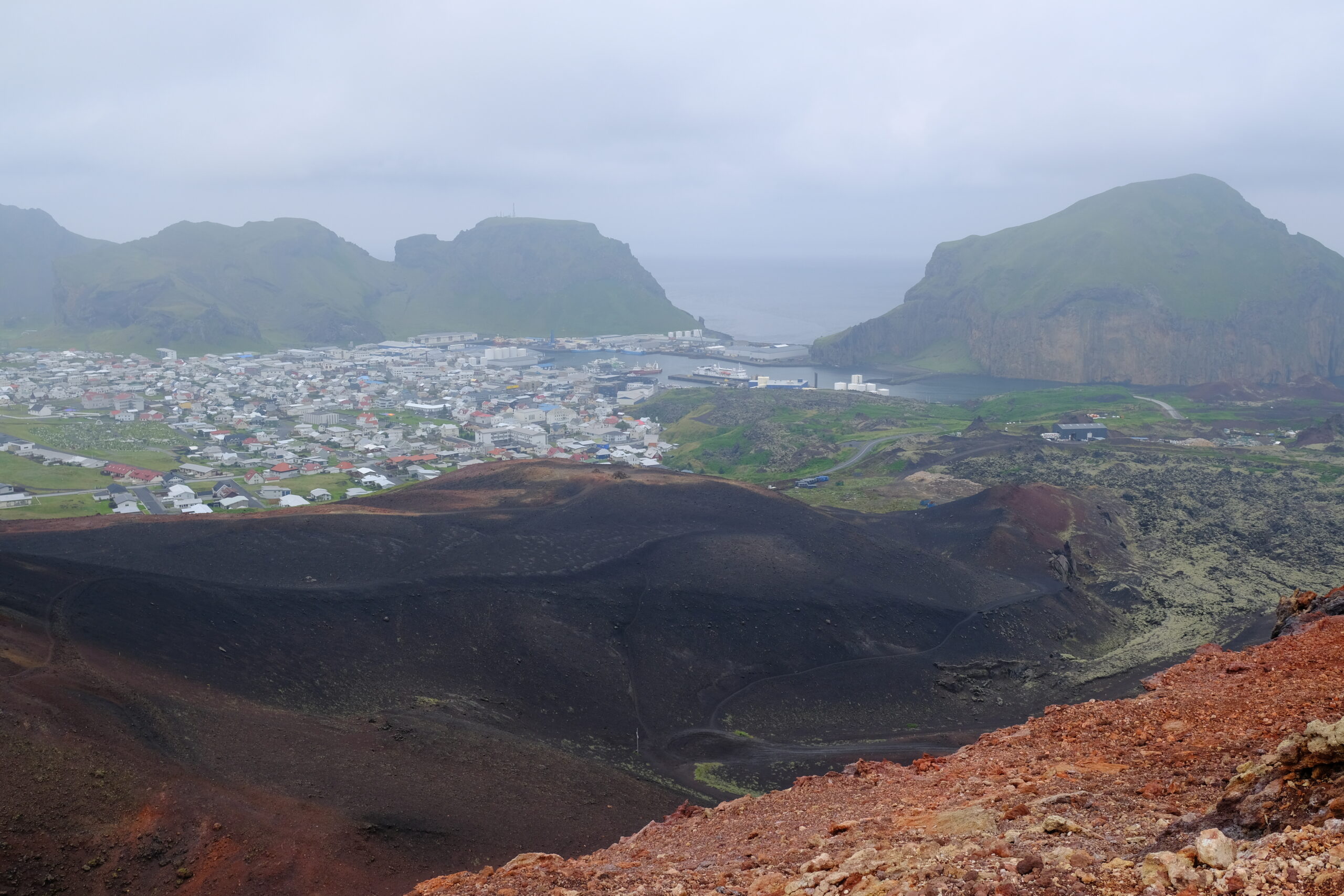
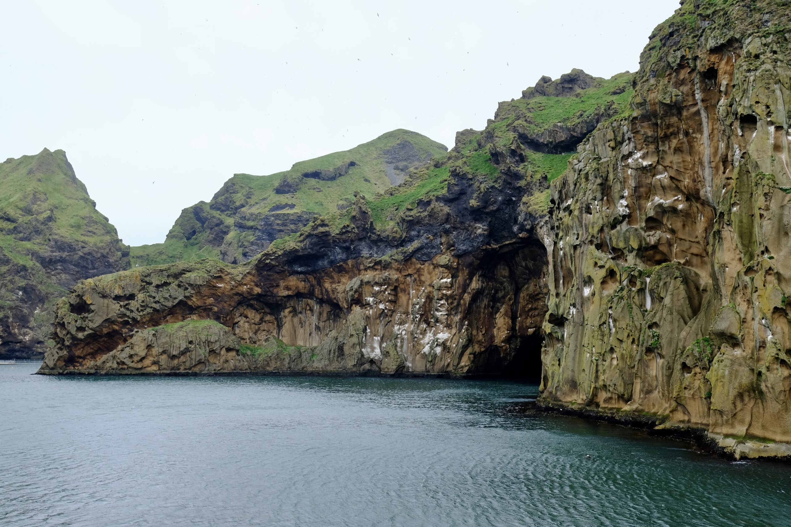
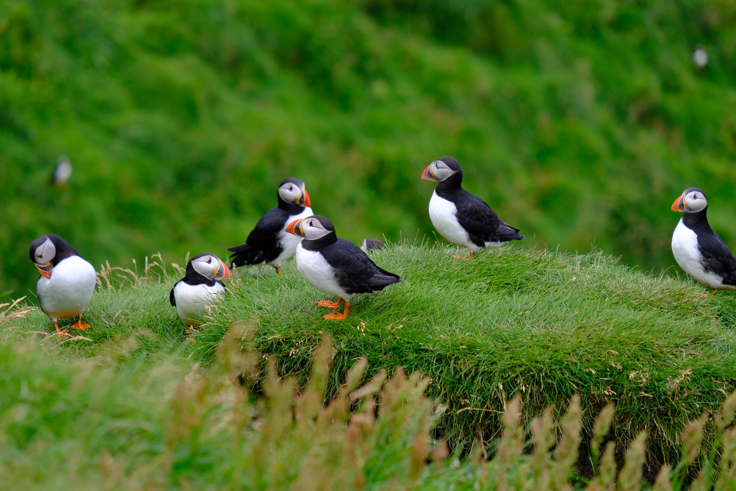
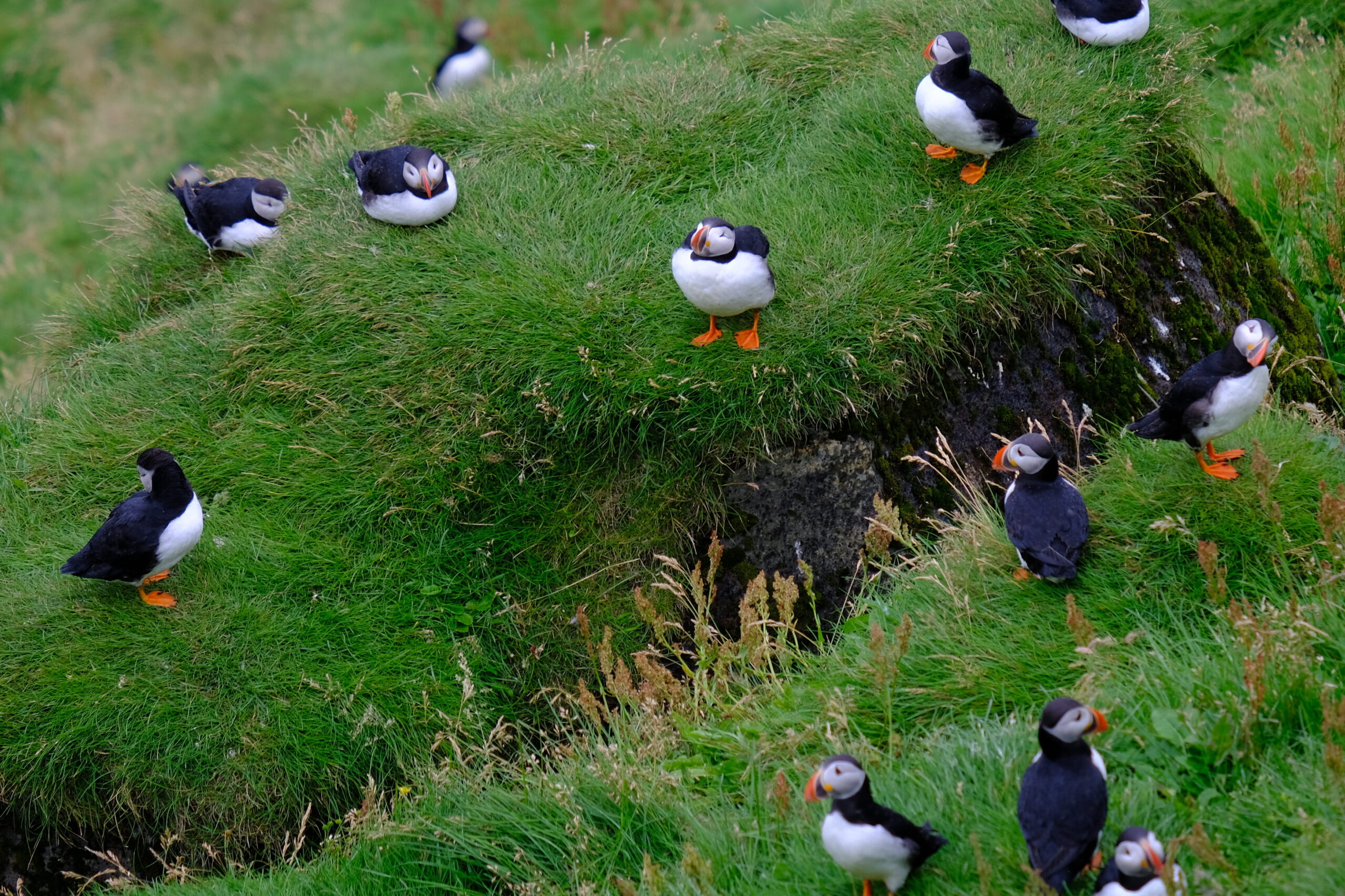
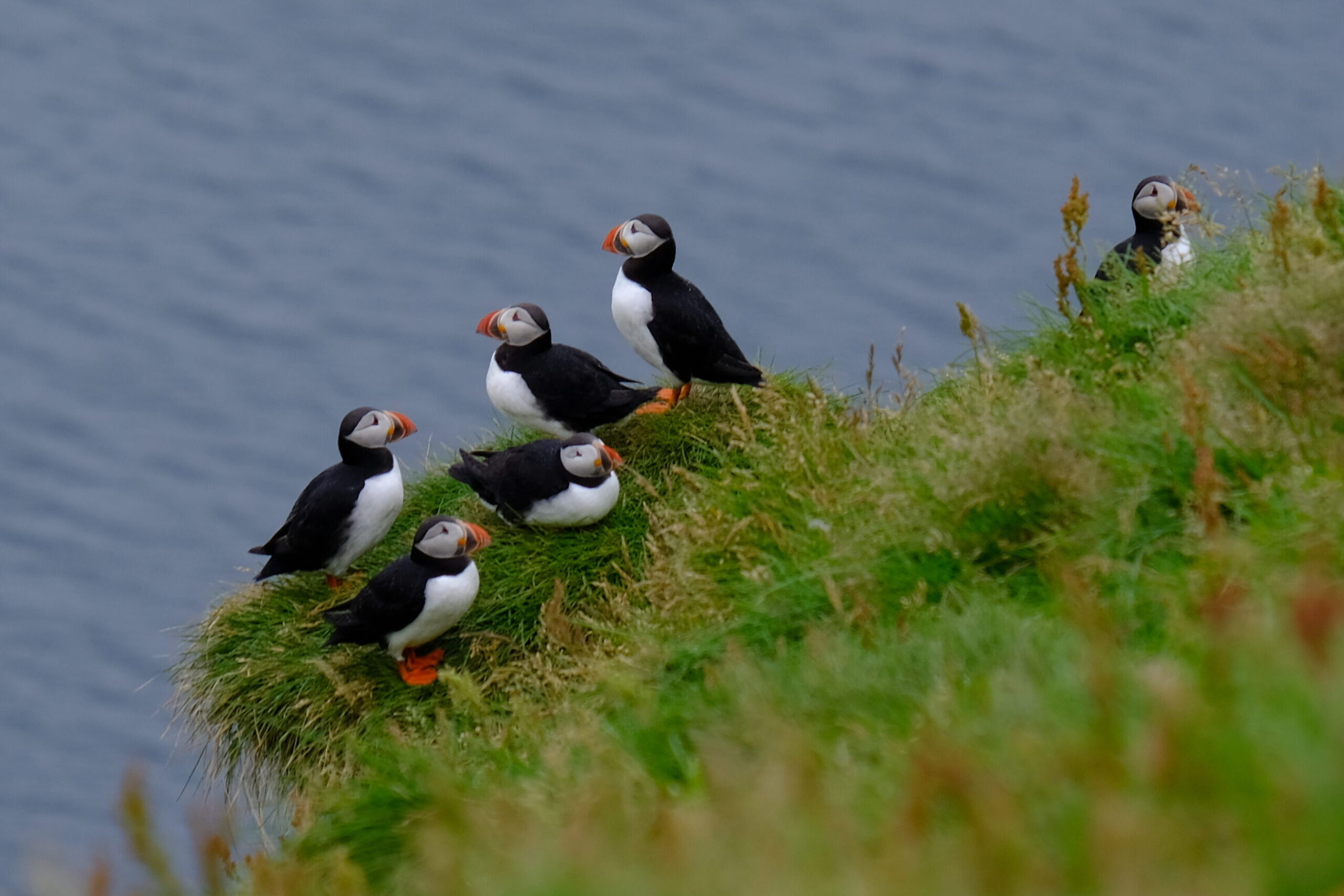
Last week started with a day-trip to Vestmannaeyjar, or the Westman Islands, an archipelago off Iceland’s southern coast that I’ve wanted to visit for a long time. Of course I did — it’s an island off an island — I’m always up for the next most isolated spot. There were a couple of things I knew about Vestmannaeyjar ahead of time: a volcanic eruption forced an evacuation in 1973 and it’s home to Europe’s largest puffin colony.
View from the top of Eldfell volcano The cliffs along the harbor
Over the last few years my interest in the islands was piqued by a few different pieces of media. The first was a movie called The Deep, a 2012 Icelandic film about the real story of a fisherman who survived a shipwreck and managed to withstand the cold of the North Atlantic for 6 hours while he swam home to Vestmannaeyjar, eventually walking dragging himself to shore and walking home across the lava fields. Great film, but hard to find.
Luckily the other two are readily available, and both about puffins. First is the 20 minute documentary Puffling (full video on Vimeo) that follows people on Vestmannaeyjar as they work to rescue baby puffins (which are called pufflings!) that get lost in the town and need to be taken back to the cliffs. And finally the New York Times Magazine writer Sam Anderson recorded a podcast about his experience of traveling to Vestmannaeyjar and rescuing pufflings. I highly recommend both.
I didn’t get a chance to save any lost pufflings, but I did get to see hundreds, if not thousands on the Stórhöfði peninsula, the southernmost tip of Heimaey island. The only experience I can compare this to was visiting Mykines island in the Faroe Islands in 2018. There, we walked amongst the burrows, watching puffins poke their heads in and out. The cliffs on Vestmannaeyjar are too steep for that, you’re looking down and across at a hill filled with burrows. But the number of puffins is noticeably greater and there is a small viewing shack that can shield you from the weather.
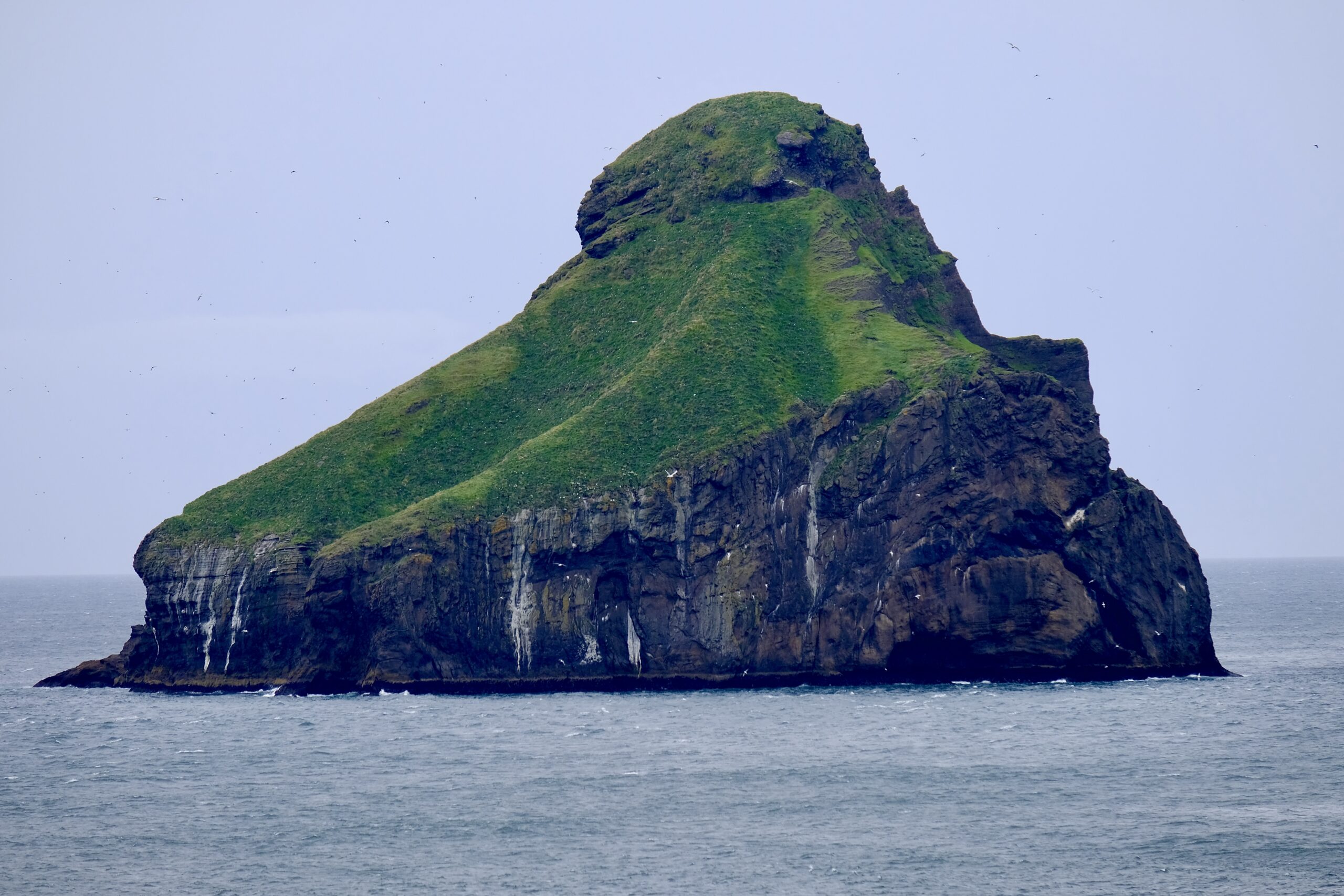
In general, the Westman Islands reminded so much of the Faroe Islands, especially the uninhabited rocks standing alone with a forbidding lack of shoreline. There are 16 islands in total, of which only Heimaey is occupied, but 6 others have a single hunting cabin perched on them, like an isolation look-alike contest with the Faroes’ Stóra Dímun. The southernmost island of Surtsey is brand new, having been formed by a volcanic eruption in just 1967.
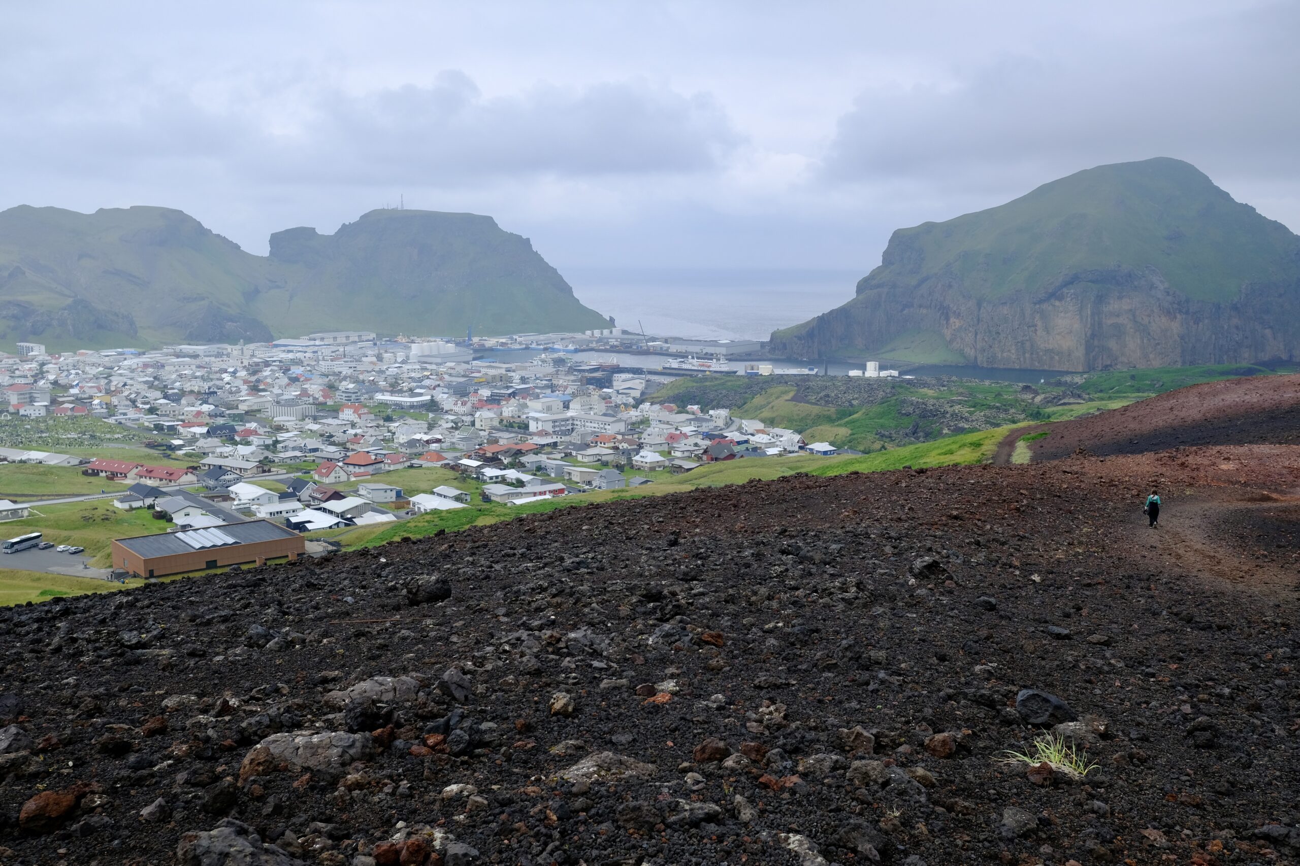
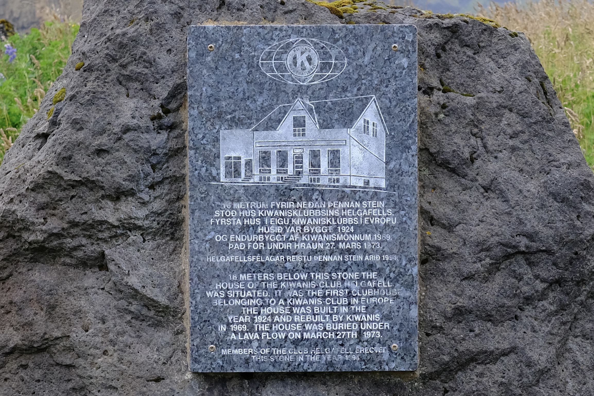
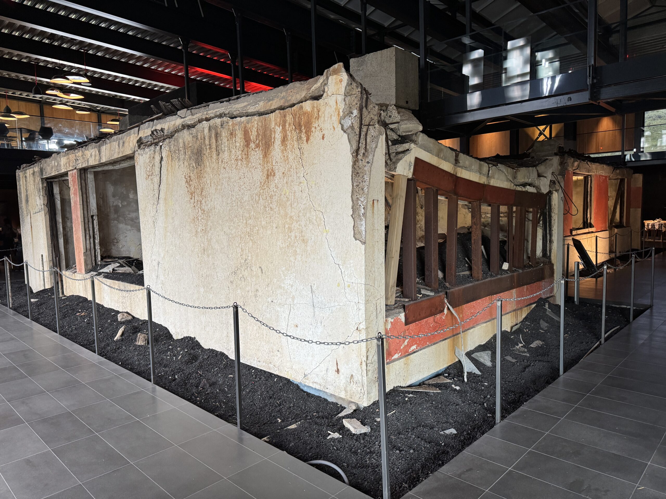
I also hiked to the top of the Eldfell volcano, the one that erupted in 1973 covering the town in ash and lava. It’s an amazing view from up there, and provides a sense of scale to the eruption and destruction. What are now lava fields were once houses, and as you walk through them there are signs indicating a house, or the church, or the power plant is buried below you. The Eldheimar museum memorializes and tells the story of the eruption, and it’s incredibly well designed. The museum building itself is constructed around a house that was excavated from the ash and left in situ.
The Eldheimar museum is the building in the bottom left.The old Kiwanis Club is 16 meters below this plaque.An excavated home that was completely covered in ash during the Eldfell eruption in 1973
In other news, I finally completed all of the administrative tasks I’d been working on. I got my residency card, after going back to the Directorate of Immigration in person to nudge them to complete it. That opened up the ability to upgrade my phone plan to full capabilities. I also got my student ID card from the University of Iceland, which gives me access to buildings after hours and entitles me to various discounts like a half-price monthly bus pass. I also made a second trip to IKEA and a local retailer Elko, and now have pretty much everything I need for my apartment.
I’m certainly not jet lagged anymore, three weeks in, but I do feel oddly time shifted in various ways. It’s probably a combination of the time zone (4 hours ahead of Eastern) and the fact that the sun doesn’t set until midnight. It’s an awkward shift, because just as I’m looking to get some sleep the work day is ending in the US, the news recaps are available on my podcasts, and many people I know are getting off work. Also, I think my body is confused by the temperature, which is in the 50s and I’m wearing a puffy coat every day. Don’t get me wrong, I very much prefer this to sweltering heat, but my body still gets confused that it’s August.
Noted & Done
Finished watching the Icelandic TV show Vitjanir, available with English subtitles as Fractures via Mhz.
Finally got a coffee maker and realized how under-caffeinated I was.